This was just one of the bridges
The Keystone Arches
Trail: keystone Arches trail
Date: Saturday 10/25/03
Attending: Simone, & John Chicoine
Miles:5-mile back and fourth Time: 3.5
Weather: Bright fall Sun. brisk clear New England air.
Location: Find Middlefield Rd. off of Rt. 20 in the center of Chester MA. The trail head begins at the start of Herbert Cross Rd. is an unmarked dirt road about 2 miles out of town and about a 1/4 mile before the town line. There is a small parking section at the mouth of the road large enough for 5 to 7 cars. The first bridge is visible to the left of the road about a hundred yards down the road just as the road comes close to the river.
Hello dudes and dudetts. This place is awesome! We loved it. The hike was on the old railroad bed (still passable by a 4-wheel drive vehicle). Aside from bushwhacking up and down the steep sides of the ravines that these bridges span, the hike is on a flat grade. The total hike is about 5miles round trip. There is a section of the trail that is marked by blue blazes where the trail branches to the right off from the road. An alternate route can be taken by following the road to the operating rail bed, then branching to the right back onto the trail (looks like a dirt road) several hundred yards after you hike along the rail bed. It took us about 3.5 hours to hike it.
It takes us about 2+ hours to drive out to the trailhead form Gardner. Unfortunately,,, The trail hear is not marked fir the Keystone Bridges, (It’s not marked at all!) We repeated to each other that “Gary and Gwenn (and Gabe) would love this”. We can think of lots of active couples that we would like to bring out there. It’s most likely not something I’ll drive 4 to 5 hours (out and back) lots of times for, but it’s definitely a “have-to-see” at least once or twice and we absolutely intend to do it a few more times while we’re bringing people out to see this. I must say these arches are best seen late fall through early spring (while the leaves are off the trees) for the best views of the bridges. (This is the perfect time to see these, (there still some color on the forest around but not enough leaves so as to block the views.) On another note! (But somewhat related because this would be a great X-country skiing trip but you would need Snowshoes to get to some of the best view spots)
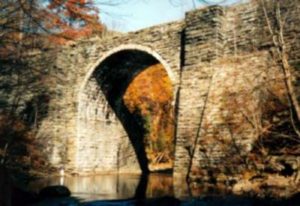
Just a note about the picture above; just to the left of the base of the bridge, next to the the water is an almost indistinguishable image/speck. That’s Simone standing next to the bridge.
This is the text on the info board about the KeyStone Arches.
The Western Railroad of Massachusetts was surveyed and engineered by Maj. George Washington Whistler in the late 1830s. It was the first railroad to cross mountains and Editor Buckingham of the Boston Courier predicted in 1827 it “would be as useless as a railroad from Boston to the moon.” The route utilized small portions of the Pontusic Turnpike stage road to Albany. It was surveyed on horseback through what to this day is some of the most remote and forbidding territory in the state. When complete the Western was the highest (1458 ft.) and longest (150 mi.) railroad in the world. Whistler was the father of one of the most famous American painters, James Macneill Whistler. His second wife, Anna, has also become an icon by way of “Portrait of the Painter’s Mother” (1871). Only Maj. Whistler, whose accomplishments were nothing short of unprecedented, remains largely unknown. The completion of this railroad in 1841 was considered so extraordinary that Whistler was summoned to Russia by Czar Nicholas I to build a 400 mi. railroad from Moscow to St. Petersburg. Today, this is known as the Trans-Siberian Railroad.
Sub contractor Alexander Birnie was the artisan responsible for the Keystone Arches. A second-generation Scottish stonemason from Stockbridge, MA, he was hired to construct 27 bridges, culverts and walls for the mountain segment of the line. On this portion of abandoned railbed, we cross two spectacular stone arch bridges, 65 and 70 ft. high and pass a breathtaking stone retaining wall. Also on this section of the rail are two impressive hand-dug cuts through solid rock. The builders of 1840 had only black powder to loosen rocks and picks, shovels and horse carts to remove it. Stone taken from the cuts was used to construct secondary walls, but for the ‘ring stones’, or ‘ voussoirs’ of the arches themselves, Chester Blue granite was utilized. This had to be transported in wagons to the railhead and brought to the site on the primitive rail equipment of the day, a formidable task in itself. Across the valley from here, we see the present relocated line on the same gradient. If you can imagine that track turning from the left to where you stand, you’ll get a pretty good idea of why it was changed. The curve was very sharp, consequently wearing out rails very quickly. In order to relocate the line, the river course was also changed. It used to come straight toward the bridge, from where the track is now. Such earth moving simply was not possible in 1840. When one considers that only two miles of 150 total was relocated when technology allowed, the genius of Whistler becomes evident. The trains you see still cross other examples of these mortar-less bridges here, testimony to their integrity. The average locomotive in 1840 weighed about 12,000 lbs. The latest locomotives of 2002, which traverse arches still in use on this line, weigh in the neighborhood of 415,000 lbs., those bridges showing no ill effects from their crossing. The heaviest locomotives these abandoned arches would have carried are the Pacifics, built in 1903. They sported 75 in. drive wheels and weighed in at 215,000 lbs.
Follow this link to the official web site for the Keystone Arches ……………. Don’t forget to come back!