Mt. Pemigewasset (2900)
Trail: Indian Head Trail (South of Indian Head Resort)
Date: Monday 3/20/00
Attending: Gabe, Simone, & John Chicoine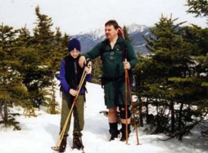
Miles: 4-mile round trip Time: 2 hours to summit. 3 hours total
AMC huts, / shelters / camping site: None
Weather: Fantastic frist day of spring, mostly sunny, in the 40’s
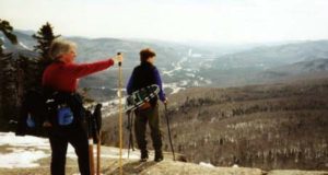
To get there from Lincoln, take 93 North and branch onto Rt. 3 North towards the Flume. Just as you see the Indian Head Resort, the trail-head on the west side of Rt. 3 is clearly marked for Indian Head. The trail is 1.7 miles of steady moderate hiking after you pass through the two bridges under Rt. 93 North and South, and 2 tenths that are steep, but no rock scrambling. The Whites got 10 inches of snow a few days before we got there, but the sun had turned this into 6 inches of heavy soft snow on top of a 10-inch solid base. This proved 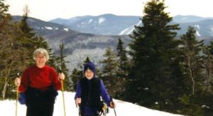 to be tiring combination to hike up on. Simone used her snowshoes for the entire assent, Gabe and I packed ours up. Simone just had to use them one last time this year. The temps were hot enough that we hiked in t-shirts and shorts. Un-knowingly, we had picked the trail less traveled; We were the first to break trail all the way up! I couldn’t believe no-one had bagged this mountain over the weekend. (This was a good thing). Especially on this trail because it is so well marked. I have never seen a trail in the Whites this heavily marked. When we reached the place where the south trail, converges with the north branch of the loop, we were blown away by how heavily that trail had been hiked. There must have been a hundred people that used that trail over the weekend. The summit of Indian Head is really nice, with some great views of the Franconia Range. We spent about 20 minutes on the summit, and headed back the way we came. As soon as we got off of the steep knob, I decided we should try trail running through the snow. It was a blast!!! The snow had softened up substantially, so we were slipping, sliding, and post holing to mid calf, like a bunch of drunken fools, whooping and laughing at ourselves all the way.
 We must have run off a mile or more of the trail. We heated up so much we started a snowball fight just to cool off. We originally intended to hike the Benton trail up the back side of Mt. Moosilauke, and after driving 1.5miles down an unplowed road, we reached a closed gate, 1.5 miles from the already 3.9 mile trail, we just couldn’t do an 11 mile hike. (It would be nice of the AMC book mentioned the road is closed in the winter.) So, we didn’t get to Indian Head trail until 10:30, but we still got back to the car by 2:00. I like days when we can get up there, hike, stop at LL-Bean, and be home by 6:00PM. And although I would most likely never bother with this trail in the summer, I highly recommend as a winter hike. But use the south branch of the trail, and avoid the crowds! Come to think of it, this is one of the few hikes in the whites that we didn’t see other hikers all day. Note! We’re not snobs; we actually like it if we see a few other hikers.