Mt Cardigan
(3155)
Trail: West Side Trail from Cardigan State Park
Date: Saturday 03/5/09
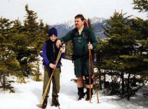
Attending: Nicky, Olivia, Simone, & John Chicoine
Miles: 3.3 mi. Time: 1.5 hours to summit. 3hr 15min. total.
AMC huts, / shelters / camping site: None
Weather: Cool and clear fall day, with a stiff wind on the summit
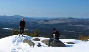
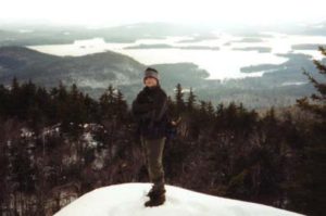
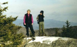
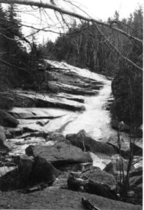
Mt. Cardigan is a wonderful mountain and if you decide to hike it from the west side it certainly lives up to its reputation as having one of the best views in New England, for the least amount of effort. In hardly more than 1.5hrs of moderate hiking you find yourself standing atop a spectacular 360 degree view with an open summit that shows off many of the high peaks in the White Mountains as well as the high peaks of the Green Mountains. This isolated peak is located far enough north in New Hampshire and just far enough west to make the high peaks of both Vermont and New Hampshire look like you could reach out and touch them. Add to the hike the extra treat of early March snow on the trail, a clear brisk winter day, 40Mph winds and the gentle warmth of the mid day sun in late winter and you have a near perfect day.
Getting there: From the AMC guide: “VIA TRAILHEADS AT CARDIGAN STATE PARK: From I-89. Get off of exit 17 and head east on Route 4 towards Enfield and Canaan. Once in Canaan make a left onto Route 118 towards Orange and Rumney. At roughly a half mile north of Canaan make a right at the Cardigan State Park sign. Bear right after crossing over a stream roughly two and a half miles. The road to the parking area (.4miles long) will be on your left, roughly a mile past the creek (closed in winter and early spring).” (Add the .4 mile easy hike to the 1.5 mile summit mileage.) The road can be quite muddy & rutty in wet conditions.
Our morning started off with a few frantic phone calls to our usual hiking buddies; considering we had only just decided to bag Cardigan that morning and we hadn’t made any prior plans with anybody. By 9:00AM it was obvious that we were going to hike this one without company. Then! I remembered what the AMC guide said about this mountain being a great candidate for a first time hike for children. We had taken our Great Niece and Nephew up Mt. Monadnock last summer and that wasn’t too bad. So we decided to bring then along for this hike. Our day started off unusually late; 10AM, with a long meandering 2.5hour drive up Rt. 10 in New Hampshire. Mt. Cardigan seems like it’s one of those “You can’t get there from here” type of locations. The most direct Rt. from central Mass. is Rt. 10, (a whistle stop 2 lane back water putt putt, that winds up the western side of New Hampshire passing the center of every village with a population greater than 10). We finally arrived at the Cardigan State Park road at 12:30 and hiked in to the trailhead by 1’ish. The outhouses at the state park were open! Very handy with kids. The trail was well marked and well packed in. At no time were there any parts of the trail that exceeded a moderate grade of hiking. Even with a 30lb pack (food and drinks for 4, crampons for 4, stove, pot, hot coco and cups for 4, and all of Nick’s and livie’s extra cloths, a heavy digital camera with 4 dead batteries, and a complete set of replacement batteries also DEAD!), the elevation gain felt very comfortable. If there were any sections that were just a little strenuous they didn’t last longer than 100ft or more.
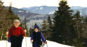
As far as the aesthetics of this mountain, (We’ve never met a mountain we didn’t like.). The Krumbholtz section near the summit is particularly pretty with nice views and lots of open space between the trees. The summit is almost identical to Mt Mondanock, (except for the fire tower.) but the views are even nicer. Considering this mountain is only 40Ft. lower than Mt. Mondanock, the hike/pleasure quotient is definitely a 10. If we had a working camera this is where we would have posted lots of very nice pictures! (for those you’ll have to check out other peoples sites, or wait for us to go up again and take a working camera. ) Speaking of going up again,,, That’s a given. Because of the wind and ice, we never made it to the high hut near the summit. (Reason #1 to hike it again), and because we didn’t have a working camera we have to go up again just for the pictures. (Reason #2), We know of at least 2 carloads of people we want to bring up there, (Reason # 3 & 4). I absolutely have to hike this as a Royal Ranger event; Reason # ….. well you get the point.). This one might just make it to the “at least once a year” list.
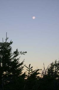
 have asked for a nicer night, (low 30’s), full moon, and a crystal clear sky. Watching the Moon come up over the Kinsmans was even better than watching the sun set over the Green mountains of Vermont. The entire event was picture perfect.
 =========================================
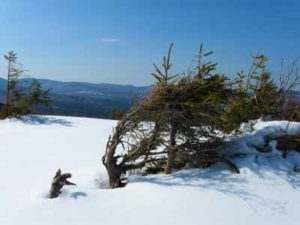
 to be tiring combination to hike up on. Simone used her snowshoes for the entire assent, Gabe and I packed ours up. Simone just had to use them one last time this year. The temps were hot enough that we hiked in t-shirts and shorts. Un-knowingly, we had picked the trail less traveled; We were the first to break trail all the way up! I couldn’t believe no-one had bagged this mountain over the weekend. (This was a good thing). Especially on this trail because it is so well marked. I have never seen a trail in the Whites this heavily marked. When we reached the place where the south trail, converges with the north branch of the loop, we were blown away by how heavily that trail had been hiked. There must have been a hundred people that used that trail over the weekend. The summit of Indian Head is really nice, with some great views of the Franconia Range. We spent about 20 minutes on the summit, and headed back the way we came. As soon as we got off of the steep knob, I decided we should try trail running through the snow. It was a blast!!! The snow had softened up substantially, so we were slipping, sliding, and post holing to mid calf, like a bunch of drunken fools, whooping and laughing at ourselves all the way.
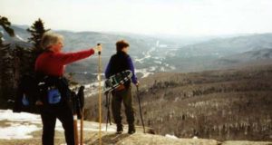 We must have run off a mile or more of the trail. We heated up so much we started a snowball fight just to cool off. We originally intended to hike the Benton trail up the back side of Mt. Moosilauke, and after driving 1.5miles down an unplowed road, we reached a closed gate, 1.5 miles from the already 3.9 mile trail, we just couldn’t do an 11 mile hike. (It would be nice of the AMC book mentioned the road is closed in the winter.) So, we didn’t get to Indian Head trail until 10:30, but we still got back to the car by 2:00. I like days when we can get up there, hike, stop at LL-Bean, and be home by 6:00PM. And although I would most likely never bother with this trail in the summer, I highly recommend as a winter hike. But use the south branch of the trail, and avoid the crowds! Come to think of it, this is one of the few hikes in the whites that we didn’t see other hikers all day. Note! We’re not snobs; we actually like it if we see a few other hikers.
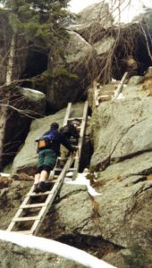
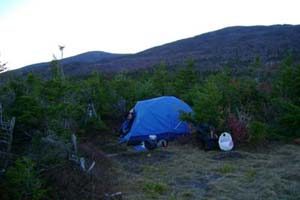
 We were back at the campsite by noon and the stove performed well enough to heat a few cups of oatmeal for lunch. The day never reached above freezing and after noon the temps began to drop again. We met a couple of hikers that hadn’t known the “eating out of your hands” habit of the Gray Jays. One of them immediately jumped up to try it, while the other looked on a bit skeptical. Within a few seconds a jay had landed in the first guy’s hand and the skeptic jumped up in amazement holding his hand full of GORP proclaiming “let me try that!”. Happens every time. We had to warn them not to feed the jays their entire supply of GORP.