Category: New Hampshire 4Ks

Flume

Mt. Flume (4328)

Trail: Lincoln Woods Tr. to Osseo Tr.

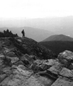
Date: Sunday 9/23/00

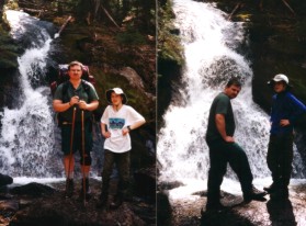
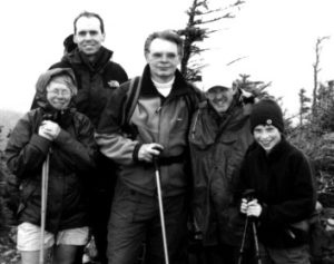
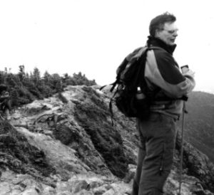
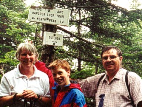
Attending: Gary, Shawn, Ralph, Gabe, Simone and John

Miles: 11 Time: 7.25 hours round trip

AMC huts, / shelters / camping site:

Weather: Cloudy, 60’s at the base, 30’s on the summit, rain the return trip.

“Climb steadily, slowly, enjoy each passing moment; and the view from the summit will serve as a fitting climax to the journey.” Joe Porcino

How could someone have asked for more? All of our favorite hiking partners, Gary Gilchrest, Shawn White, Ralph Chicoine, Gabe, Simone & me. A wonderful trail! An awesome summit! Temps in the low 60’s, COLD driving wind and rain on the peak, (we were all prepared for this), and a gentle shower for most of the return hike; Topped with a high cloud ceiling, affording us interesting views of all of the surrounding mountains.

Another spectacular hike in the Whites. #38. The Osseo trail is an absolute must hike trail. Nowhere in the Whites is there another trail quite so impeccably well maintained. What a pleasure to hike. Shawn hiked the trail in his running sneakers and Simone hiked the entire trail in her hiking sandals. I want to be careful that I don’t imply that this hike as an easy hike. Osseo climbs steadily along it’s 4.1 mile length, and the elevation is substantial, 3150ft. The total round trip mileage is at the upper limits of our day hike capabilities, 11 miles, but this trail has a way of making all those things as pleasant as any trail in the Whites. At every location where the trail could present a section of difficult footing, there is a rock staircase. And where other trails would have you rock scrambling through eroded bolder paths, this trail has lengths of wooden staircases. I can’t confirm this, but I do not contest it; it was published on the internet that between rock & wooden steps, this trail has 396 stairs. All of which lead you to one of the most striking summit peaks in the Whites. The Flume is an awesome peak open 360 degrees. The summit affords one of the most unique views of the Franconia range and the Pemigewassett wilderness; and the short ledge section to the peak is fantastic!

The cloud ceiling was just hovering at the tops of the high peaks and

the views were limited to 30 miles under a dark sky, but we loved it. The wind was near 40Mph and it started to rain just after we got to the summit. Our return trip was in and out of a moderate rain, but the hike back was another treat. Other than the rock & wood steps the rest of the trail is soft forest floor. We hiked as speedily and comfortably as we have on any trail we’ve ever hiked. The AMC guide estimated 4.25 hours to the summit, we hiked it in 3.45 and the return trip took just over 3 hours. 11 miles, in 7hrs and 15min. with a 15 minute stay on the summit and a few much needed breaks along the way. (Not bad for trail snails.)

A note for future hikes. Although the Osseo trail follows very close along a river, it does so from several hundred feet above it so filtering water along the way is a difficult proposition. We did it, but the trip to the river is down and up a long steep embankment. (Best to pack all the fluid you’ll need for the entire trip.) There is a nice but illegal site (right on the side of the trail) within 1/2 mile from the summit of the peak. It looks very heavily used and recent people that used this trail didn’t know much about low impact camping.

A note of interest: We noticed a berry we’ve never seen before. It formed a cluster of 15 to 20 white glossy berries at the top of the plant. Each berry was on it’s own thick red stem about 1 inch long, branching out from the main trunk of the 2ft. tall plant. Each branch contained a berry, and was about 1/2 inch away from the next stem up the trunk. According to “The Audubon Society’s Guide to Wildflowers”, this is the “very poisonous” White Baneberry.

A comment by Gary about “Why Hike?” He loves the social aspect of the hike. I agree! In what other situation can people get together and have continual conversations for hours on end, about anything, everything, and nothing in particular at all? Where it’s just as OK to not say anything as it is to say something. Where you can share thoughts that might never elsewhere surface. Where a nucleus group share in a physical challenge, place their safety and even life in the partnership formed at the trailhead. Where personal goals, even shared goals, are second to the groups needs. Where else can holes in someone’s sweater, pain in someone’s feet, and the reward for one of the hardest days you’ve faced is a 3 hour ride in the stinky’ist 20 cubic feet known to man, make you a brotherhood. It’s good stuff. Where else can you share day old cake kept in the trunk of a car, eaten with your hands while standing in a parking lot and feel like the luckiest people alive!

Gailhead

“The Wilderness holds answers to questions man has not yet learned how to ask.” Nancy Newhall

Mt. Galehead (4024)

Trail: Gailhead River trail off Gale River fire rd. (closes in winter), Frost Trail.

Date: October 19, 1998

Attending: Paul, Matt and Nicole LeBlanc, Gabe, Simone, & John Chicoine

Miles: 10.2-miles Time: 7.5 Hrs.

AMC huts, / shelters / camping site: Gailhead hut (it was closed for the season)

Weather: Partly sunny, Overcast (very high ceiling) 60’ish,

Our first hike with Paul and his family. The whole family was supposed to come along, but Sarah was sick so Joanne stayed home with her. Can these guys hike! We hustled our butts off this day. These guys are on a mission. I don’t think they hardly take the time to look up. We hit the trail at 9:00 and finished by 4:30. Ten miles. The first 2.5 miles is just a flat hike along the Gale River valley. The next section of the hike is a well-maintained gradual (slightly more than moderate climb up to Galehead hut.) We really liked the trail. It’s a lot like Edmonds path up Mt. Eisenhowser. From the hut, it’s another .5 miles on Frost Trail to Galehead’s wooded summit spot. (a clearing barely big enough to fit the six of us for a picture). We had lunch on the porch of the Galehead hut, (I forgot our lunch food) (AMATURE), but we had lots of snacks and Paul had packed food for five so he had plenty of extra.

From the porch of the Gailhead hut, the views of the Twin 
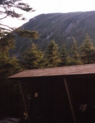
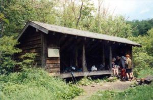
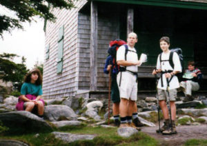
Mountains were great, but the autumn leaves were all but gone. The hills were gray and sullen, as they waited for the cold of winter to fall upon them. We used the same trail back to get to the car. Simone and I couldn’t keep up with Paul and his clan. We tried, but we were hustling and stumbling along just trying to keep up. Simone slipped knee deep into the river at one of the crossings. It was a blessing in disguise because her toes were just starting to cramp up and the cold water dunking stopped the pain. The last mile or so seemed to go on forever. We were real glad to see the car. Something tells me that we may never be invited to hike with Paul like this again. We loved the company, (sometimes it makes all the difference in the world to have someone else with us on our hike), but I just don’t think we’re a match. Not that there was anything wrong with the hike, or the day. We’re just too slow,,,, We don’t mind that we’re slow. We like it that way. We couldn’t change that if we tried. Note! The AMC rebuilt the hut the next year after we visited it; it wasn’t open when we were there, so we never saw what it was like inside, but the outside didn’t look all that bad. I guess we’ll have to hike it again just to see the new hut.

Read another trip Report to Mt. Gailhead:

Gailhead1

Gailhead (4024)

Trail: Gailhead River trail off Gale River fire rd. (closes in winter), Frost Trail.

Date: November 4 2000

Attending: Ralph, Gabe, Simone, & John Chicoine

Miles: 10.2-miles Time: 7 Hrs.

AMC huts, / shelters / camping site: New Gailhead hut (it was closed for the season)

Weather: Mostley sunny, 50’ish,

Our first snow hike of the 2000/01-winter season. We got to the trailhead at 9:30 and it was a wonderful day for a hike. I had been reading recent trip reports and most of them made no mention of snow, so I wasn’t expecting as much snow as we found on the trails. We started hiking with just a dusting of snow at the trail-head but within the first 2 miles as the trail slowly and gradually picks up a few hundred feet of elevation, the snow depths increased to quite a few inches deep. The trail began to show lots of water saturation beneath the snow cover (an inch deep of slush). The third mile of the hike (after the last river crossing begins to gain some more serious elevation and so increased the snow depth to 6+ inches, with several inches on the trail. The last mile to the Gailhead hut had between 8 and 10 inches of snow in the woods, and the trail was fully covered with trampled snow. The trail itself wasn’t over traveled, but it was well broken up to the hut. The trail to Gailhead summit was quite a bit less traveled and had lots of muddy sections on the trail where the sun melted the path.

There seemed to be 5 parties on the trail today; a single lady, a party of 4 in their late 40’s, a group of 3 girls in their late 30’s, a pair of men from Sweden, (first time hiking the whites), and us. It seemed like we all must have hit the trail within a few minutes of each other and all reached the parking lot within a ten-minute gap.

As much as this hike was a delightful hike, it was a bitter sweet. Our goal for this hike was not Gailhead, but South Twin. Three times now we have stood within an hour of the summit and have not summited. On this hike we reached the Twinway only to find that it had not been broken out yet. We had not come prepared to break trail. We did attempt to venture up none the less but found that every step was very slippery and without a trail, we could not see the water and mud under the snow. Within the first 50 feet Gabe stepped into a mud puddle that soaked in over the top of his boots. (Boots I might add that were beginning to loose the front 2-inch section of the sole), but the Gore-Tex liner still kept his feet drier than most of us. My old leather hikers had soaked through well before we reached the hut but the temps were warm enough that nobody’s feet got cold. Just as I remembered from our first trek to Gailhead the trek out of the valley along the river seems to take forever and we ended our trip back at the car at 4:30, just a few minutes before sunset. When we got back to the car I noticed my tire was 1/2 flat so we decided to change the tire while I still had light. That’s when we found out that this car had no lug wrench and only a doughnut spare tire. We drove to the nearest gas station filled the tire and hoped for the best; Praise God, it got us home!

Garfield

“And forget not that the earth delights to feel your bare feet and the winds long to play with your hair.”
Kahlil Gibran

Mt. Garfield (4500)

Trail: Garfield Trail, off Gail River Rd.

Date: Nov. 5 1999

Attending: Gabe, Simone, & John Chicoine

Miles:9.5 Round trip Time: 3.5 hrs up, 6.5 hrs. Total

AMC huts, / shelters / camping site:

Weather: Temps in the 60’s, On the Summit the wind was too! (60Mph).

This is mountain # 30, in just 14 months and a few days. I didn’t think we’d bag another 4K this year but the weather has been exceptionally warm this late in the season. September and early October had far more snow than late October. Almost all the snow was gone from the warm weather. This trail is definitely going to be a repeater. Although it is 10 miles, it is not particularly difficult at any time and it does move along quite fast. At this time of the season there were lots of leaf covered muddy sections between the 2 and 3-mile stretch. We removed about 7 small blow downs, (one of which required a full family effort to drag it off the trail), leaving only one tree that still would cause someone to have to step off the trail. (It has been quite windy this fall up here.) As was reported on the internet a few days before we hiked this, the top 1/4 mile was quite icy and there was a dusting of snow to make things a bit slicker, but we made it through on bare boots and our buts at times. The summit of Garfield surprised us, we weren’t expecting it so soon, we turned a corner through the trees and there we were on the summit. We could here the “mighty rushing wind” for the last 1/2 hour up o the summit, but had no idea of it’s ferocity until we reached the open summit. This is one of the few hikes in the Whites that we didn’t see another car in the parking lot, and we never saw any other hikers.

We will have to remember to bring extra food for the Gray Jays on our next Garfield hike. They were more persistent than we’ve ever seen them. We had them eating off Gabe’s head. They ate most of our Fig-Newtons. One even followed us for about a mile down the trail and as we reached his cut off point, he squawked at us to stop and feed him some more, We did. We love this mountain. It was clear, cold, and windy. Very windy! At one point while firmly grasping one of the re-bar posts on the foundation of the old fire lookout on the summit, I had to grab Gabe and hold him down, to keep from having him blown away, I estimate gusts exceeded 65Mph. It just doesn’t get any better than this.


Hale

Mt. Hale (4054)

Trail: Hale Brook Trail

Date: May 15’Th 1999

Attending: Gabe, Simone, & John Chicoine

Miles: 4.4Miles Round trip Time: 2.5hrs up, 5hrs. Total

AMC huts, / shelters / camping site:

Weather: Sunny, mid 50’s at base, 40’ish on summit no wind, hot sun,

“Our life is frittered away by detail… simplify, simplify.” Henry David Thoreau

What can I say, just another one of the 4K’s. Hale is a good bail out mountain to keep in your back pocket when something blows a big hike, like unexpected foul weather or something. The day we hiked, the air was comfortable but the afternoon sun heated up the damp trail and made it like a steam bath. Lots of little things kept going wrong with this hike, we forgot our poles; I ended up with only Gabe’s hiking socks. Thank God this was a little one. The trail itself is OK, but nothing to write home about. This would be a good “Non-Peak-Bagger” family type of hike. The Summit of Hale is a large rock and moss covered dome surrounded with trees just tall enough to block about 70% of the views. Nobody seemed to be in any rush on the summit, it felt more like a small town common on a sunny Sunday afternoon with people waiting about for the town band to show up and play. We did enjoy a nice 1/2hr. nap in the springtime sun on the thick mossy patches that are reclaiming the summit. Quite a bit really, more than enough to provide a good spot in the sun to start working on the tan.

If it wasn’t so far down Zealand road (closed in the winter) I’d say that this would be quite a nice winter 4K. None the less, I think I’ll have to stop being such a snob and give this mountain the respect it deserves and visit the summit a few times. Maybe I can switch between Osceola and Hale for bringing new-bies up into the Whites. I almost hate to say this here, but this summit would be a fantastic place to set up a tent and spend a nice starlit night.

Hancocks

Hancocks (North and South) (4420, 4319)

Trail: Hancock Notch, Cedar Brook, to Hancock Loop.
Date:
Saturday 8/12 2000
Attending:
Gabe, Simone, John Chicoine, & Gary Gilchrest
Miles:
10 Time: 7 hours total.
AMC huts, / shelters / camping site:

Weather:
Partly cloudy, 70 to 75

This was #35 & #36 of the 48, just 1 week before our second anniversary of our 4K-peak bagging obsession. We were all quite a bit apprehensive at the prospect hiking this set of mountains. It had been 10 month’s since Gary’s last 4K, and at least 6 weeks since ours. A ten mile loop, with two mountains bearing the phrase “un-relieving” as the AMC guide book described the last 1/2; mile to either summit, after a 2.5 mile easy to moderate approach. Terms like loose scree, steep, and 5 dangerous water crossings at high water (this has been one of the wettest summers in recent history), and last night was a deluge. I slept very little the night before; Were we up for the mileage? How bad was the heavy rain outside my bedroom window effecting those many river crossings, would the knees hold up?

The truth of this trail is that it may just be a bit over vilified in the AMC guide book. Not to take anything away from the effort it takes to bag these peaks, (a lot). But I compare the effort to any other 10 mile trek, like the Lafayette/Lincoln Franconia loop. The Hancock Notch trail is a very easy/flat walk on a well-trodden dirt path. Most of the Cedar Brook trail is the same. The trails have very little bolder hopping. Because of this they are prone to muddy sections. The upper sections of the Cedar brook trail are only moderately steep. The Hancock loop trail begins the only real steep hiking. Either approaches, north or south are almost identical in terrain, length, and difficulty. I recommend using the north approach to summit the pair. Having invested the effort the rest of the sag between North and South peaks is almost all down hill and from South peak it’s only slightly less steep than it’s north peak counterpart. As always it was a good time of fellowship with Gary and Gabe truly enjoys the endless conversations with Gary about everything from books to birds. The hike itself was a bit un-exciting, (we only had limited views for a short time as we ate lunch on the North Peak lookout and we were totally clouded in by the time we got to South peak). The trail is rather plain and other than .5 mile steep section, wasn’t any big deal. I do strongly recommend keeping the AMC guide and map handy and keeping very careful count of the river crossings because there is a lot of opportunity to loose track of the real trail. There are a lot of bush whacked trails that are heavily traveled and camped on lower sections of the Hancock Notch and Cedar Brook trails.

There were lots of opportunities for the foot washing and we took the first one we crossed on our trip back down. Even though we still had several miles and lots of water to cross to finish the hike it was nice to cool the dogs down so early in the trip. We hiked very close to book time (6.5hrs.) and we were all happy to complete the trip by 4:30PM. I don’t think I’ll ever forget the two characters we met on the steep section coming down from South Hancock. Not that they were particularly unique or anything or that we exchanged more than a few sentences with them. It’s more what they said that I won’t forget. As we passed them while they were taking a few moments to rest; they excused themselves for taking a break in the trail but they needed to give their “recently operated on knees a rest”. So what’s that about, two people hiking a ten mile loop, with two mountains, just weeks after reconstructive Knee surgery? Some physical therapy routine!

This was a day for another interesting conversation that has resulted in shifting our hiking experience into a new plane. Extended backpacking. It had been on my mind for a while now, (I think it was mostly an effort to get out of bagging 4K’s.) but as we were recovering from the hike in the car, I happened to mention that it might be cool to section hike the Massachusetts section of the AT. Gary’s eyes lit up like a Christmas Tree. It seems I’d surfaced a life long dream of Gary’s, (I mean really life long, he actually purchased the trail guide for the Massachusetts section of the AT in 1972.) From that moment on, it was going to be a done deal here it was August and we decided to do the Massachusetts Section next July during the first week of Gary’s vacation. We were all in! Now we just had to tell Shawn what to expect next summer.

Isolation

Shawn gets head over heals happy when you take him hiking!


Mt. Isolation (4003)

Trail: Rocky Branch Tr, Isolation Tr, Davis Path

Date: Friday & Saturday, July 5’th & 6’th

Attending: Shawn, Gabe, Simone and John

Miles: 10.9 Friday/ 3.7 Saturday / 14.6 Total Time: 7.5Hrs. Friday, 3Hrs. Saturday

AMC huts, / shelters / camping site: Rocky Branch Shelter #2

“I care not what others think of what I do, but I care very much about what I think of what I do! That is character!” Theodore Roosevelt


Knocking off another 4K (#43). It sure has been a while since we’ve bagged one of these. This was supposed to be a 1-week AT hike through Connecticut. (It’s real tough to get the schedules of 5 people to work out so that you can pre-plan an entire week. It just wasn’t going to work out. No Problem! We just cut the trip down to 4 days and continue knocking off another section of the Vermont AT. More issues, more juggling and we’re down to 2 days on the NH AT… Transportation logistics issues with the two-car issue and we’re down to hiking Isolation for 2 days with 1 car. So many trails, so many trails.

A note to anyone thinking of making this into an overnighter. The Shelter at the foot of Isolation is on it’s last legs and is not going to be maintained. It is unlikely to be there much longer. The new camp site is located before the river crossing.

We started at the Rt.16 Rocky Branch trailhead. (Note! this is a pay parking lot but you can’t purchase a parking pass there.) Our annual pass expired 3 days before we hiked. It was getting later than I wanted to start hiking so we took a chance; the next trail head up, does let you buy day passes so we purchased one and used the drop box at the Rocky Branch for the money. (It worked!) The trail starts out with a 2.8-mile steady/moderate incline to the height of the land. (With full packs for the first time in a long time, and high humidity I would have to say this was a hard “moderate” stretch.) From the height of the land on Rocky Branch to Davis Path the trail was wet. We ditched our packs at the shelter and continued to the summit with daypacks. Showers that never amounted to more than sprinkles continually threatened the last 2 hours of the hike to the top. The summit was socked in with fog; No views! Bummer! But we were glad to be there nonetheless. Temps we app 50’ish, but with the steady 30+Mph wind it didn’t take us long to get cold, (considering the previous week was in the mid 90’s every day we were all happy to get bone chilling cold. Cool!)

We got back to settle in at the shelter by 7PM. We cooked the usual dried ramen / dried vegie meal and decided to set up the tents inside the shelter. By 8:30PM a moderate steady rain started for a few hours.
The next morning was still overcast, but nice enough for us to spend 30 minutes lounging around the rocks on the river before we packed out. I need to add one final note. PAIN!!! My body has betrayed me again! Within 100 yards from the summit on the first day, my left groin muscle tightened up so bad it was killing me to take every step. Boy was I glad to get back to the shelter and stop walking. On Saturday morning I thought I was feeling better but within the first ¼mile nothing was taking the edge off the pain of every step. Thank God we only had 1 mile of very moderate up hill and only 3.7 miles total to the car. I have got to get into regular exercise that solves that issue.

Jackson

“The goal of life is to make your heartbeat match the beat of the universe,
to match your nature with Nature.”

Joseph Campbell

Mt. Jackson (4052)


Trail:
Webster Jackson trail

Date: October 11 1998
Attending:
Gabe, Simone, & John Chicoine
Miles:
5.2 Time: 5.5Hrs
AMC huts, / shelters / camping site:
None
Weather:
Rainny, 60 at base, 20’ish on summit,

This is a very nice trail. We didn’t get to the trailhead until 12:00 on Sunday, because we stopped at EMS to purchase our System 3 foul weather shells at the annual Columbus Day tent sail. (We paid too much, $80 bucks each, we found one for Noah for $40 at Peterborough that had some stitching problems inside the pit zips.) But! They made this hike do-able. It was raining! Just the right time to try out the new gear. It had been raining for the previous 4 days up in the Whites so the trail was saturated and 2″ deep mud. What wasn’t mud was a flowing stream down the trail. It was 1/2-inch deep water cascading over the stones. We loved it! At one point we had to ford a small river, we hooked our poles together to form a handrail for Gabe to hold onto while rock hopping. The summit is a 50′ hands and knees rock scramble up a bolder side onto the final peak (plenty safe in dry or even wet weather.). One minute you’re in the woods, and the next, you’re standing on a large krumholtz covered dome.

On the way up 
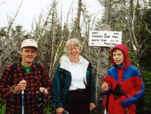
we kept noticing people all bundled up in winter gear, coming from the summit, we couldn’t figure it out, we were getting wet, but we were warm, in shorts even. But, as soon as we reached the summit we found out why people were so bundled up. The Temps with the wind chill had to be below 20, with horizontal rain/sleet. Needless to say we didn’t stay on the summit long. There was nothing to see beyond 60 feet, and it was so cold that we could hardly stand it long enough to snap a picture. I was afraid the rock scramble we just did to reach the summit, might start to ice up. We made it down to the car, at 5:30. Gabe was cold, we were all wet, and muddy. No foot washing today, but echo lake is just across the street from the Crawford Notch RR station where we picked up the trail. Quack Quack.

Read about other Jackson hikes


Jackson2

Mt. Jackson

Trail: Webster Jackson trail

Date: June 10, 2001

Attending: Gabe, Simone, & John Chicoine

Miles: 5.2 Time: 5.5Hrs

AMC huts, / shelters / camping site: None

Weather: Sunny, 80 at base, 70’ish on summit,

Where have we been? I can’t believe this is our first 4K this year. We’ve been so busy this winter snow shoeing and x-country Skiing that we never bothered to make the long trip up north. We tried for Ocseola in May, but Tripolli Rd. was still closed so we hit the ever wonderful Welch-Dickey loop. It seems I’d been fooling myself into thinking that I was staying in shape over the winter by doing lots of X-country skiing. Here in North Central Mass, we were X-country skiing the back side of Mount Wachusett to the summit into the second week of April. As soon as the skiing was done, we hit the bikes.

But! Nothing works the body like a true 4K hike. We enjoyed Jackson last time we hiked it, but there was such extreme weather (driving sleet and thick fog) that we couldn’t see 30ft. This time the sun was shining, the temps were warm, and the views were abundant. Jackson has a very nice viewpoint. I rather doubt that Jackson would ever take the place of Mt. Pierce as a winter hike, but the views are almost as nice. We were treated to an abundance of White Lady Slippers (we’re used to pink, and even yellow, but never remember seeing white). The Trilliums were out too, along with other flowers. Gabe even spotted a 4 petal Trillium. We had no idea such a thing existed. We took a picture in case no one believed us. There were lots of people out on the trails on this hike, and we enjoyed 45 minutes on the summit before we headed down. We were all tired from this one, (not bone exhausted, but tired). The hike down to the car took us as long as it took us to hike up. We had a few sun showers on the trip down, “Thanks God”. We did stop to enjoy a longer than usual, ritual foot washing in one of the rivers on the trail. This was a prep hike for our AT Massachusetts section hike in a few weeks. If this was a test, I failed! I am not in the kind of shape I need to be in for the rigors of an 8-day, 100 mile hike. My knees are not going to be my friends. (I’ve still got 3 weeks to work on it.)

Kinsman

“Great things are done when men and mountains meet.”
William Blake

North and South Kinsmans (4293, 4358)


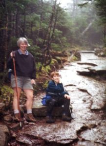
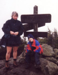
Trail: Mt. Kinsman trail, Kinsman Ridge Trail,
Date:
May 4 & 5 2000
Attending:
Gabe, Simone, John
Miles:
(day 1) 4 miles to Kinsmans Pond shelter, : (day 2) 3 miles round trip to South Peak, 3.5 miles back to Rt.116
AMC huts, / shelters / camping site:
Kinsman Pond Shelter
Weather:
Day 1 sunny, 70ish, very light winds. Day 2 wet, cloudy.

This was our first over-night backpacking trip this year. #’s 31 and 32. I was not in shape for it yet; I was beat after the first mile. If we would have met up with a lawyer on the trail, I would have filed for divorce. Simone just had to have this one. She just kept on moving up hill. I knew we were in for snow, ice, wet/cold boots, rain and possibly a very cold night, and Friday’s weather was iffy.

Day one: We hit the trail at 11:30, I was counting every step. The trailhead is not marked, but the AMC guide book gets you there. I don’t know why they didn’t mention the two stone gate pillars that are the trailhead. There are three nice river crossings, and several spots that you have to visit. There are some nice water falls just up stream from the lower crossing, and the flume is worth the 100 yard side trip. The views from the .1 mile trip to Bald Knob is well worth the time, for that matter,,, Bald knob is not a bad destination in itself. Here’s those stone pillars. The Franconia Town line sign is about 15 feet to the left of this picture. 
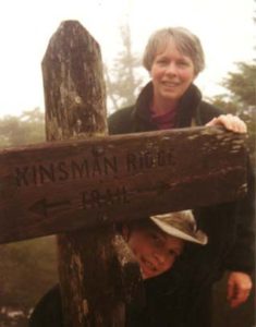
Just after leaving Bald Knob, the trail turned to mud, hard packed snow, and ice patches. The Ice patches were generally passable, and the hard packed snow held well over the running springs. We post-holed a few times, and all of our boots were beginning to soak up the wet. We got to the Kinsman Ridge trail at 5:00, where the trail was quite a bit more traveled and harder packed. Our trek down to the pond shelter took another 15 minutes of careful navigation. We expected to have the mountain alone, and we did. I set up our tent in the shelter hoping to help keep the wind off of us for the night, and hoping that if the predicted “possible showers”, turned into a snow storm, we would be a bit more comfortable. Fortunately the temps did not drop much below 40’ish, and we all had as good a sleep as one can have on a backpacking trip. The “posible showers” were a steady rain from 10PM to 6AM. PRAISE BE TO GOD, it stopped at 6AM!!! Regardless, I knew all that water wasn’t going to be a good thing, I suspected we might have to abort the attempt to bag the Kinsmans.

Day two: Within the first step out of the hut my fears were confirmed. Much of the hard packed snow that afforded good footing yesterday, was now large wet ice patches. Without Crampons, we had to take care to place every step, and plant those poles before each one. But, all was not catastrophic, I think the rain packed the trail on the Kinsman Ridge even harder. We dropped our packs on the trail at the Mt. Kinsman Trail junction, and with Grit, and Wit, we forged on, up to North Kinsman, and over the top towards South Kinsman. Again! PRAISE God, the south side of North Kinsman, was mostly clear, with only hard packed snow in the woods in the flat col between North and South. Not a view to be had, we were socked in the clouds, even the pictures of each other 30 feet away came out too foggy to scan. Although it wasn’t raining, everything was damp to soaked, and what brushed and or blew off the trees felt like a gentle rain. The wind was real mild, and the temps were in the high 40’s by 9AM.

Back at the junction, and loaded with our packs we soon found out that the less packed Mt. Kinsman trail had softened substantially from the rain. Today, we post-holed often, and none of the snow bridges were holding. Thank God we only had a mile of this type of hiking, it was painful and frustrating. The boots now were twice their weight with water, but we were on our way home, and the temps kept getting warmer as we dropped down the trail. Simone post-holed and bruised her knee just as we were leaving the last of the snow. The trail had lots of running water everywhere, and as we approached our first river crossing on the way down we knew the sound of the river had substantially changed from the river we crossed yesterday. It was fine, (It sounded a lot worse than it was.) but there was no way to cross without getting our feet wet a bit. (like it mattered at this point) We had to do the “hop, skip, plop and lunge for shore”.


Here’s a couple of before and after pictures, side by side of a spot on the river we shot on both days. Gabe and I are standing almost in the exact same spots in both pictures.

By the time we crossed our last river, the sun had come out, The Kinsmans were in clear view with just a few high clouds above, and the Trout Lilies were in bloom. The last mile was a great trek down a gentle dry cart road. The picture at the gate/trailhead was taken at the end of the trip. We were makin time, we were going home. All safe, slightly bruised, and completely victorious over our own challenges. Simone loved this kind of trip; I did too, but I wouldn’t set out to intentionally have an experience like this. She would! I think I could make a good case of cruel and unusual abuse of a husband. Why do we always have to hike up something?

I got lucky with my glasses on this one. I left them in the side pouch of the tent in the morning and rolled the tent up into a tiny little ball and stuffed it into the stuff sack. I didn’t notice I didn’t have my glasses until I got back down to the car and needed them to drive. This was beginning of the ten year long granny glasses tie loops phase. (I had those stupid glasses hanging around my neck for a long long time.)

In retrospect, we all had lots of fun, and I suspect when conversations start up about hiking in the Whites, (as they always do) this trip will get a lot of favorable press.

Read about another North Kinsman trip with an overnight stop on Bald Peak!