Category: New Hampshire 4Ks

Kinsman2

“I went to the woods because I wished to live deliberately, to front only the essential facts of life, and see if I could not learn what it had to teach, and not, when I came to die, discover that I had not lived.”
Henry David Thoreau

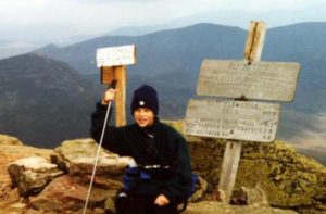
North Kinsman (4293, 4358)

Trail: Mt. Kinsman trail, Kinsman Ridge Trail,

Date: September 5 & 6 2009

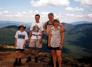
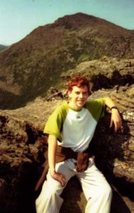
Attending: Shawn White, Simone, John

Miles: (day 1) 2 miles to Bald Peak shelter, : (day 2) 2 miles round trip to North Kinsman, 3.4 miles back to Rt.116

AMC huts, / shelters / camping site: Kinsman Pond Shelter

Weather: Day 1 sunny, 70ish, very light winds. Day 2 sunny, 70ish, no wind.

Back to our favorite over night camping spot in the Whites, Bald Peak. It was nice to see that as of this year, Bald Peak/the Mt. Kinsman trail now has it’s own trail head parking lot, (located just 2 tenth’s of a mile from the old entrance of the trail head.).

Day one: We knew we had low mileage and lots of time to get to the intended tent site, so we didn’t get to the trail until 1:30ish. This was Shawn’s first time on this trail and as usual he hardly broke a sweat keeping a slow pace for Simone and I. This was Simone’s and my first backpacking trip in a year, come to think of it, this was our first 4K in a year. (We just aren’t doing this enough anymore!). Even with our packs relatively light, (Mid 30Lb’s), and considering the weather was perfect for hiking, we seemed to just slog along at a snail’s pace. Shawn on the other hand had spent a couple of weeks hiking the 100-mile wilderness on the Maine AT earlier this summer and was in great shape. Shawn had lots of light new gear, (his pack was under 30Lb’s) so that has to explain why he had such an easy time.

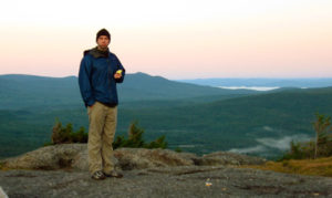
It took us just a little over 2 hours to get to Bald Peak. We got there about an hour before a spectacular sun set over the western mountains of New Hampshire and Vermont. At just about 2500 feet, Bald Peak is one of the nicest open exposure summits I would even consider setting up a tent for an overnighter. The views are wonderful and when the sun goes down, the sparse lights in the houses and towns below are a pleasant treat. Another pleasant treat was the evening Fireworks in one of the townships just within viewing range. But that was only act two of our wonderful evening. When the full moon rose through the clear cool mountain air over North Kinsman peak!!! That was wicked cool. Within minutes the place light up with moonlight bright enough to play cards by the moonlight. Really! Simone brought some cards!

The rock face of Bald Peak retained the heat of the previously sunny day for several hours, and Shawn couldn’t resist sleeping out beneath the stars in just his sleeping bag. (Remember the new gear thing,,, his 15 degree bag still keeps him warm down to 15 degrees. (Although we’re quite sure it didn’t get down much less than the mid 30’s.) Simone and I were just right in our bags in our tent.

Day two: Sunday morning was as nice a morning as anyone could ask for. From the clear mountain air, we watched as the thick mist in the valley below began to swirl upwards and burn off from the warmth of the morning sun. We cooked a pot of hot water for tea and oatmeal as we let the dry air dry due off of our tent and shawn’s sleeping bag.

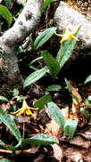
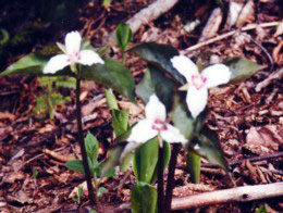
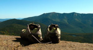
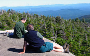
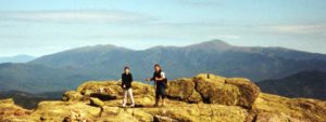
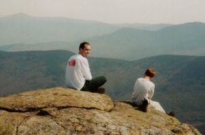
Simone and I opted to ditch our full packs into the woods and complete the morning hike up North Kinsman with just a few snacks and a couple of liters of Gatorade in a day pack. Shawn hiked with his full pack. (Show off!) Even though Bald Peak is half way up the Kinsman trail, that second half on Sunday morning was still quite a serious haul for us old folk. Simone and I just didn’t expect that these last 2 miles up to North Kinsman would be such a tough slog. (The last and only time we did this hike the trail it was covered in several feet of snow, and we were 10 years younger.) I have to say, it was well worth the effort. The last time we hiked the Kinsmans the fog was so thick you could hardly see the person walking in front of you; This time the air was cool and crisp and the views were spectacular. We didn’t even know there was a view spot on North Kinsman, but what a nice spot, and what a great view of the Lafayette ridge. We must have spent at least an hour enjoying the view, and the company. It was a popular spot! We must have had 30 or more hikers join us in just that 1 hour.

The hike down to the car took us a solid 3 hours with just a short break to fill the water bottles. Both times we’ve spent a night there we’ve done so without guests. But, this really is a popular trail and Bald Peak is a top attraction for people on the Franconia side of the range. We will be doing this again; maybe next time we’ll see you up there.

Shawn taught us about his latest water treatment kit. He’s using AquaMira, a two part water treatment (replacement for the old iodine pills) that really doesn’t taste that bad. I’m sold! It’s a lot lighter and smaller than the full filter pump and a lot less hassle in sub freezing conditions.

Lafayette

“In the long run, men hit only what they aim at. Therefore, they had better aim at something high.” Henry David Thoreau

Mt. Lafayette (5266)Trail: Falling Waters, to Franconia Ridge trail (Part of the Appalachian Trail) to The Old Bridle path.

Date: Monday, September 25 1998

Attending: Gabe, Simone, & John Chicoine

Miles: 8.9-mile loop

Time: 9 hours , Little Haystack (4700), Lincoln (5089)

AMC huts, / shelters / camping site: Greenleaf hut Weather: Sunny, 70 to 75,

This is our first trip over the Lafayette Ridge. We parked at the Old Bridle Path trailhead on the north side of the Franconia Notch Parkway Rt93. We started up the Old Bridle path and veered off to the right up the Falling Waters trail to the top of Little Haystack (about 3 hrs). The lower part of the trail has lots of nice water falls and long switchbacks to make the hiking enjoyable. We enjoyed hiking this loop up Falling Waters; most people take the loop in the other direction but that way the falls are to your back. From Haystack we walked the Franconia Ridge trail to Mt Lincoln (not a spectacular summit, it’s nothing more than a peak on the ridge trail on the way to Lafayette, we didn’t even stop there to take pictures of us at the summit.) Mt. Lafayette on the other hand is quite a peak. It towers above all the rest and commands an audience. There is an old foundation on it’s summit from another age when there used to be a hotel there. Unbelievable! Our decent looped over to the Greenleaf hut via the Old Bridle path. The hut is about 1/4 of the way down, but it sits in a perfect location for views of the Franconia range. Gabe purchased a patch for his collection of hut patches. The hut was booked-up for the night, offering 80 people 2 meals and a bunk for $55 a night. The hike could be done in less than 8 hrs, but an hour for viewing and resting is just barely enough.

I don’t want to imply this hike isn’t a tough pull. 9 miles anywhere in the Whites requires a serious effort and with Lafayette being the 6’th hightest peak of the 4K’s it takes it’s toll. A warning to the wise, plan on being above tree line for close to 2hrs. and the weather can change on Lafayette in no time at all. Weather fronts from the west hit this high paek first and a nice sunny summer day can get wet and windy quick. This peak tends get socked in with fog a lot and if you’re doing this one in the winter, plan for potential worst case situations. Hardly a winter passes without several hikers getting into unexpected serious difficulties.

May God Bless and be safe!

Read about Lafayette trip 1:

Read about Lafayette trip 2:

Read about Lafayette trip 3:


Lafayette2

Mt. Lafayette (5266)


Falling Waters, to Franconia Ridge trail
(Part of the Appalachian Trail) to The Old Bridle path.

Date:
Monday, July 11’th 1999
Attending:
Abby Trembly, Kevin Maycomber, Gabe, Simone, & John Chicoine
Miles:
8.9-mile loop Time: 9. hours, Little Haystack (4700), Lincoln (5089)
AMC huts, / shelters / camping site:
Greenleaf hut
Weather:
Sunny, 70 to 75

The 3 hour long car ride started @ 5:30AM: We got to the Falling Waters trailhead at 9:00. The trail parking lot is clearly posted on Rt. 93 just after the Flume parking lot. Simone and I packed the two Kelty Redwings with food, water, and vests for everyone.

This was Abby’s and Kevin’s first 4K hike. We knew that this isn’t a “first hike” kind of trip, but the views from the ridge are some of the best in the Whites. And if this is likeley to be the one and only 4K someone is going to bag, it’s one that will stick with a person for a lifetime. We all shared carrying the 25Lb. packs over the course of the day. Falling Waters trail is spectacular with more waterfalls than we could bother to shoot between the three cameras that made the trip. The summit of Little Haystack was a great spot for lunch and our first long break @ 12:30. By 1:00 we started the Franconia Ridge portion of the trip. 1.3 long miles above the tree line, walking the knife-edge the views over the Pemigiwassit wilderness were great. With the binoculars we could see the cliffs on Bond Cliff where we were just a few weeks before. To our west across Rt. 93, were the Cannon balls and the Kinsman’s. We met Beverly again,(The retired through hiker we met on our Bonds trip.). She was clipping brush just before the steep climb up Lafayette. She was staying at Greenleaf hut on the AMC’s tab while she spent a few days doing some trail maintenance. Our next extended break was on top of Lafayette, the 5’Th highest peak in the Whites. A few non-threatening clouds gave us a little shade as we started the next stretch down the rocky path to the Greenleaf hut. We got to the hut at a little after 3:00 and rested there until 3:30. Greenleaf provided us much needed fresh water and bathrooms for Simone and Abby.

Our final leg down the camel back of Lafayette on the Old Bridle Path trail was a bit steeper than I remembered. It took a full 2.5 hours to get to the footbridge where the Falling Waters trail and the Bridle Path complete the loop, just a quarter of a mile from the parking lot. We stopped at the river for the traditional foot washing and wash up. As we went splashing about knee deep in the river, washing sweaty brows, and pits,,,, Kevin didn’t seem to understand the appeal to this whole washing up and wading in ice water process. What fun is a tradition if it doesn’t cost you something.

Trip 3–>

Lafayette3

Mt. Lafayette (5266)


Trail: Falling Waters, to Franconia Ridge trail
(Part of the Appalachian Trail) to The Old Bridle path.

Date:
Sunday, June 13’th 2004
Attending:
The Awesome Threesome, (Gabe, Simone & John)
Miles:
8.9-mile loop Time: 7.5 hours, Little Haystack (4700), Lincoln (5089)
AMC huts, / shelters / camping site:
Greenleaf hut
Weather:
Sunny, 70 to 75

Another great day for another great hike. Life is always changing for the Chicoine family and adapting to the impact on our world is sometimes a bit of a challenge. Gabes’ getting older now and his life is filling up with responsibilities of his own. He needs a job to keep his car fed and save a little bit for college. His school work for his Junior year has been taking a bit more time and focus. He’s got the pressure of SAT’s and ACT’s, finding and applying to a college, and trying to figure out what to pick for a major. With Simone working so many weekends at Cushing and with Gabe’s and my Royal Ranger weekend commitments our schedules are finding fewer and fewer connections. I’m glad for every opportunity we get to spend another day together.

This particular loop is a getting to be big investment for me; It’s definitely one I need the best of conditions for. This was our third time for this loop for us. The hike up Falling Waters is steep and relentless. We were under a bit of a deadline today, (We had to have Gabe home early enough to complete a major homework assignment.) so Simone and I did our best to keep the pace up. We sumitted Mt. Haystack in 2hrs 30 minutes (30 minutes under book time) and enjoyed a 30 minute lunch. The trek from Haystack to Lincoln took 35 minutes and from Lincoln to Lafayette another 40 minutes. It had been a tough hike for me to keep up this pace to get to that point in that time. (The combination of the hard miles and trying to “step up the pace” had made this hard work.) When I finally sat down on the Summit of Laffayett, I just melted into the rocks. Simone on the other hand was her usual self, pointing out various peaks we’ve been on, or even worse, (at that particular moment) pointing out various peaks we’ve yet to be on but are sure to get to someday. I must have been “one with the rocks” for about 20 minutes before we had to move on. Gabe wanted to see how fast he could get from the summit to the hut, (1.1 miles); so he bugged out on us leaving us to hobble along. His time was 20 minutes, ours was 42. It was obvious that we weren’t going to get back to the car by my intended 4:00 deadline; we were just leaving the hut at 2:30 and the book time said 2hrs 40 minutes back to the parking lot. The wind had stopped and the temps warmed up a bit for the last couple of hours. We kept up our pace as best as we could and managed to complete this last leg down the Bridal Path in 2 hours including a 5 minute stop to splash in the brook at the bottom. Now I really was beat and the drive home seemed endless.

There were lots of people on the ridge this weekend, if I had to guess at least 100 or so. There were lots of people in their 60’s (not unusual but they have my respect for sure). There was even one couple that brought a very young baby (3 or 4 months) in a Kelty Kid carrier. The Green Leaf hut looked full up for the night. Every time we hike this loop we can think of several friends that haven’t done this one yet that we know we just have to get them up here. The waterfalls on the Falling Waters trail are some of the best in the Whites, and for just an hour or more of hiking (app. 1 mile) it would be worth the trip up here for any avid shutter bug. I sure wish things had worked out with several of the people I invited to come along with us this time; then I could be assured that I wouldn’t have to hike the loop again soon. Nice as it is, I have to admit it just costs me too much in effort and pain to complete the loop. It took me a day to recover from this trip. If I could just loose about 50 lbs I’m sure that this one would be an annual hike. But, I don’t doubt that I’ll find my feet walking the Franconia Ridge at least a few more times in my life regardless of my weight.

Sad note: Between the last time we hiked this and now, a husband and wife from Massachusetts were traped in unexpected white out conditions above the treeline. These were very experienced hikers and well within their comfort level. They were rescued from the top after 2 days of a very difficlut time hunkered down in snow caves, but not in time to save the wife. It’s a risk most of us know exists, we plan, we pick our hikes according to our physical limitations and our experience/skill level, but the unexpected happens.

Boston News: Brenda and Russell Cox were married outdoors in the Vermont mountains seven years ago with a layer of new-fallen snow around them. Last Monday night, after the couple took shelter from a storm in a mountaintop cave in New Hampshire, Russell Cox reached for his wife, and felt that she had stopped shivering and her skin was cold. “Brenda died doing what she loved to do, and I think that that makes me happy,” Cox said Monday at Massachusetts General Hospital, where he’s been since rescuers found him last Tuesday outside the snowy cave where his wife died in the night.

My family wishes to extend our heart felt sorrows to this young man.

People that don’t hike don’t understand why or how anybody would invest this type of effort and accept these types of risks.

We keep hiking.

See ya at the top,

and May God Bless.

Madison

Mt. Madison (5367)

Trail: Valley Way up, Air Line down

Date: Saturday, July 13’th

Attending: Shawn, Gabe, Simone and John

Miles: 18.4Time: 8Hrs.

AMC huts, / shelters / camping site: Madison

Weather: Partly cloudy, high 70’s at the base, 50’s on the summit

Gabe with Mt. Adams behind him.

“Aim above morality. Be not simply good, be good for something.”
Henry David Thoreau

And a wonderful time was had by all on # 44 for us. Just 6 days after our Mt. Isolation hike we hit the road for another great adventure. This time we needed to hit the trail as early as possible so we opted to head for the mountains on Friday night to camp out at the Dolly Cop Campground. (Dolly Cop is a very nice place to drop a tent for a few nights. It was quiet, clean and the sites were nice; all for only $16 a night.) We’ll use this as a base camp again for sure. We got to the Valley Way trailhead by 7:30AM and divided up into two teams. Shawn and Gabe headed up ahead of us at their pace and Simone and I followed behind. Shawn and Gabe were going to bag Madison and meet us back at Madison hut for lunch. They would then begin their Northern Presidential hike over Adams and Jefferson, and then descend down the Caps Ridge trail. Simone and I would then go on to bag Madison for ourselves and head back down Madison over the Air Line trail to the car. If we timed it right, we would get to the Caps Ridge trailhead in sync with Shawn and Gabe. It worked perfect! We pulled into the parking lot just 15 minutes before they walked out of the woods. (A note for future reference; the Jefferson Notch road is off of Valley Road on Rt. 2. just a few miles up from Lowes garage.)

The Valley Way trail was just the moderate hike I needed. I was nursing a pulled groin muscle up the trail, and to my unspeakable joy, I completed the hike in no more than just a slight bit of discomfort. (I think I found a new day hiking trick, hiking in a pair of solid hiking sneakers with my Spenco hiking inserts.)

Madison is a great mountain peak in good weather but it would be 20+ minutes of total exposure in bad weather on .4 miles of difficult/ slippery rock scrambling above the hut. The Air Line trail is full of spectacular views into Kings Ravine, but not without a price. The lower 2/3 of the trail is much steeper than any section of the Valley Way trail and I invested as much effort going down the Air Line as I did hiking up the Valley Way. Shawn and Gabe loved the time and miles spent above the tree line. (3 new mountains for Shawn, COOL) The only regret I have is that we didn’t spend the night at one of the Randolph Mountain huts.

Southtwin

“Nature is too thin a screen; the glory of the omnipresent God bursts through everywhere. Ralph Waldo Emerson

South Twin (4902)

Trail: North Twin Mountain tr. & South Twin Spur.
Date:
Sunday 09/29/00
Attending:
Gabe, Simone and John
Miles:
11.2 Time: 8 hours round trip
AMC huts, / shelters / camping site:

Weather:
Clear, high 60’s at the base, 50’s on the summit


(((( . . . WE did it! . . . ))))

Exactly 363 days ago we tried to complete this hike and FAILED! (Does that mean we’re getting better at this as we get older?)

How many times can I say, “Another spectacular hike in the Whites.”? This was #46 for us. With good weather and God’s good blessings, we’ll bag the last 2 (Cabot and Waumbek) on a 2 day hike this Columbus Day, just 14 days from now. (All 48 in 4 years.)

The last time we attempted this hike I just didn’t have it in me to continue on to South Twin. I was beat, my asthma was acting up, and I just didn’t have it in me to pull any more elevation. Now that I’ve completed the hike, I know I would have been a suffering fool had I forced myself to finish the hike that day as we had planned. I’m not sure what the difference was on this trip, but our memory of the hike was that getting to North Twin was a very hard hike, and making it to South Twin would require everything we could give it. This time, we all loved the hike and all thought that bagging North Twin wasn’t bad at all (still hard but not a real killer) and adding the South Twin loop just made this a long but do-able trip; definitely one we might do again. When we got back to the car we all were tried, but not as bone tired as we’ve been on many other hikes.

Some of the following paragraph is a repeat from the North Twin page:

The Trailhead starts at the end of fire road # 304 off Rt. 302. The first 2 miles meander along the Twin River, crossing it 3 times. (The second crossing can be easily avoided by following a well beaten bush-whacked trail to the third crossing). (I’m going to add a personal observation here; If for some reason you were able to make it across the first river crossing, but absolutely couldn’t/wouldn’t/shouldn’t make it over the second river crossing, then don’t count on the third river crossing being any easier.) I can see why all the trail descriptions warn about dangerous high water crossings. What was little more than a nice brook for us to bound from rock to rock over, could easily be a serious rushing river to contend with. During these 2 miles, the elevation gain is only 500 ft. After the 3’rd river crossing the trail begins its serious assent. (We filtered our last fill up at the last river crossing on the Twin River.) For the next mile or so, the trail crosses 3 small tributary brooks that look as though they are reliable enough to filter from. The trail climbs steadily and on the steep side of moderate for most of these last 2 miles. At times the trail does hit a few stretches that are steep, almost rock scrambling steep.

The trail itself is nothing out of the ordinary. Other than 1 view spot just a few moments from the major view spots near the summit, there is not much to look at. The top 2 miles of this trail has lots of small stones. Little ankle twisters ranging in size from golf ball to baseball size.

The South Twin Spur looks more difficult than it is.

(Looking at it from North Twin). It loops quite a bit onto the left shoulder of the peak so you don’t really have any very steep sections to climb. Starting down off North Twin has two large rocks to scramble off of, but they aren’t too difficult. After that, all of the hiking in the col over to South Twin is pretty moderate hiking. (That said, it is 2.6 miles there and back so it will consume time and energy.)

We didn’t have Shawn with us on this trip, but not to worry, I think we’ll definitely get him up here on some other nice cool fall day. We did however meet a nice man from Connecticut that joined us on the hike. We met him trying to figure out how to cross the third river crossing. The water was up just a bit from heavy rains the previous few days, but it wasn’t a real difficult crossing. Once we all managed to get across, we just tended to stick together for the rest of the day. The 8 hour hike time includes at least 1 hour of hanging around the various peaks and lookouts. We really had a great day for this. We hit the trailhead at 9:00AM. We bagged North Twin in just over 3 hours and spent 10 minutes lingering on the first knob on North Twin. We were on South Twin by 1:00 and we spent at least 30-minutes on South Twin peak. We stopped again another 15 minutes on North Twin’s west side lookout. We got to the car by 5:00PM and were all feeling pretty good about ourselves.


Three times we’ve tried to bag you, and three times we’ve failed; But NOT TODAY my friend!

Lafayette1

“In the long run, men hit only what they aim at. Therefore, they had better aim at something high.”
Henry David Thoreau

Mt. Lafayette (5266)


Trail:
Falling Waters, to Franconia Ridge trail (Part of the Appalachian Trail) to The Old Bridle path.
Date:
Monday, September 25 1998
Attending:
Gabe, Simone, & John Chicoine
Miles:
8.9-mile loop
Time: 9 hours , Little Haystack (4700), Lincoln (5089)
AMC huts, / shelters / camping site:
Greenleaf hut
Weather:
Sunny, 70 to 75,

This is our first trip over the Lafayette Ridge. We parked at the Old Bridle Path trailhead on the north side of the Franconia Notch Parkway Rt93. We started up the Old Bridle path and veered off to the right up the Falling Waters trail to the top of Little Haystack (about 3 hrs). The lower part of the trail has lots of nice water falls and long switchbacks to make the hiking enjoyable. We enjoyed hiking this loop up Falling Waters; most people take the loop in the other direction but that way the falls are to your back. From Haystack we walked the Franconia Ridge trail to Mt Lincoln (not a spectacular summit, it’s nothing more than a peak on the ridge trail on the way to Lafayette, we didn’t even stop there to take pictures of us at the summit.) Mt. Lafayette on the other hand is quite a peak. It towers above all the rest and commands an audience. There is an old foundation on it’s summit from another age when there used to be a hotel there. Unbelievable! Our decent looped over to the Greenleaf hut via the Old Bridle path. The hut is about 1/4 of the way down, but it sits in a perfect location for views of the Franconia range. Gabe purchased a patch for his collection of hut patches. The hut was booked-up for the night, offering 80 people 2 meals and a bunk for $55 a night. The hike could be done in less than 8 hrs, but an hour for viewing and resting is just barely enough.

I don’t want to imply this hike isn’t a tough pull. 9 miles anywhere in the Whites requires a serious effort and with Lafayette being the 6’th highest peak of the 4K’s it takes it’s toll. A warning to the wise, plan on being above tree line for close to 2hrs. and the weather can change on Lafayette in no time at all. Weather fronts from the west hit this high peak first and a nice sunny summer day can get wet and windy quick. This peak tends get socked in with fog a lot and if you’re doing this one in the winter, plan for potential worst case situations. Hardly a winter passes without several hikers getting into unexpected serious difficulties.

May God Bless and be safe!

Read about trip 2

Read about trip 3

Northtwin

“Laws change; people die;
the land remains.”
. . . Abraham Lincoln

North Twin (4761)

Trail: North Twin Mountain tr.

Date: Sunday 10/1/00

Attending: Shawn, Gabe, Simone and John

Miles: 9 Time: 7.25 hours round trip

AMC huts, / shelters / camping site:

Weather: Clear, high 60’s at the base, 50’s on the summit


Happy Birthday Noah!, Sorry we were up north today, but you know we love you.

How many times can I say, “Another spectacular hike in the Whites.” #39. Hopefully Every time!,,,

We had planed to make this #39 & 40, but I just didn’t have it in me. South Twin looked so far away and I was totally beat. Sure I could have done the dead and pushed on to bag them both but it would have made the trip just another peak bagging day with no joy in mudville. Instead, the rest of the group willingly opted to lay about on the sunny open outlooks of North Twin and enjoy the extra hour on the top. The views were fine, the sun was pleasant and the gentle breeze didn’t even make a sound. It was so very peaceful. We knew it had to end, but none of us were in any hurry to leave the top.

The Trailhead starts at the end of fire road # 304 off Rt. 302. The first 2 miles meander along the Twin River crossing it 3 times. I can see why all the trail descriptions warn about dangerous high water crossings. What was little more than a nice brook for us to bound from rock to rock over, could easily be a serious rushing river to contend with. During these 2 miles the elevation gain is only 500 ft. After the 3’rd river crossing the trail begins its serious assent. For the next mile or so the trail crosses a small tributary brook that looks as though it is reliable enough to filter from. (We filtered our last fill up at the last river crossing on the Twin River.) The trail climbs steadily and on the steep side of moderate for most of these last 2 miles. At times the trail does hit a few stretches that are just plain steep, but not rock scrambling steep, just: “This is tiring me out kind of steep”. Both Simone and I experienced more pain in our legs in the days following the hike, then we can remember since we’ve been hiking regularly.

The trail it self is nothing out of the ordinary. Other than 1 view spot just a few moments from the major view spots near the summit, there is not much to look at. There is one thing worth mentioning that although is not unique, it did seem a little excessive on this trail. The top 2 miles of this trail has lots of small stones. Little ankle twisters ranging in size from golf ball to baseball size. Simone and I were a bit concerned about this anomaly, especially with Simone hiking in sandals.

While we were on the summit we were buzzed by one of the local Glider Plane tours. He was so close that you could hear him swoosh through the wind as he flew by. We also met a man that had just come from South Twin. He had a small collie dog with him that seemed to be in her glory. He told us that she was only 1 year old, but this was the 16’Th 4K she had shared with him. He almost had us convinced that we should try to bag South Twin while we were this close but my body just wasn’t buying it.

Wildcats

People do not decide to become extraordinary. They decide to accomplish extraordinary things.” Sir Edmund Hillary

Wildcat A, thru Wildcat E

(A=4422, B=4330, C=4298, D=4062, E=4046)

Trail: 19 Mile Brook – Carter Notch Hut, Wildcat Ridge Trail to Wildcat Mt. Ski trail
Date:
5/26&27 2000
Participants:
John and Simone, Gabriel Chicoine
Miles:
Day 1, 3.8-miles to Carter Notch hut. Time: 2.5 hrs
Miles:
Day 2, 6-miles from Hut to Rt. 16 @ Wildcat Ski LodgeTime: 5.5hrs
AMC huts, / shelters / camping site:
Carter Notch Hut
Weather:
5/26&27 Cloudy, drizzle, rain.

These were # 33 & 34 of the 4K quest. We were ducking the clouds and dodging the rain drops all the way. This “peak bagging” is a complicated game. You don’t want to hike in extreme heat and you don’t want to hike in peak bug season. You don’t want to hike in extreme cold and you don’t want to get caught in a snow storm. You don’t want to get caught in driving rain; you do have to keep your job and you do need to HIKE! Lining up all these things is a losing proposition at best. Hopefully the loss is only one that cost’s you a little discomfort. I’m a fair weather hiker and proud of it! Unfortunately the White Mountains don’t know this about me. We watched the weather, prayed some and thought we found a two day window where all the elements lined up well enough. On Tuesday morning we reserved 3 beds at Carter Notch Hut for Thursday night. The only problem… rain was predicted for Thursday morning with a forecast for a spectacular Friday and more rain returning Saturday. No problem. We couldn’t get to the trailhead until 12:00’ish on Thursday (rain would be over 😉 and we would be out of there by 3:00 p.m. Friday. SURE!!! The week long rain stalled the moment we reserved the hut. Revised forecast,,, “Rain, Rain, & then, a little Rain.”

Day 1: The drive north rained so hard that cars that didn’t pull to the side of the road hydroplaned off the road. It rained like this most of the way up. At Pinkham Notch we waited as the rain slowed to a light rain. We put on our rain gear and drove the three miles to the 19 Mile Brook trailhead. The rain stopped… We hiked for a few moments in the rain gear watching storm clouds overhead. We stuffed the gear in the packs and hiked really quickly. Just as we reached the lakes at the hut the rain started up again. We made it! Damp but not soaked. It did clear up enough to scramble out over the Ramparts, (a rock pile that slid from the side of Carter Dome into the notch between Wildcat A and Carter Dome forming the lakes at the hut. What a nice location. The hut is caretaker only year round for $20 a night. Nice 4 and 6 person private sleeping rooms in two bunkhouses that can accommodate a total of 40 people. The hut has hot and cold running water, a large 6 burner gas stove and oven, pots and pans, and gas lights. You need to provide your own light in your own sleeping room. The bunks have mats and pillows. I spent most of the night listening to the wind and rain. From my estimation a steady 40’ish with stronger gusts often mixed with rain. I went over tomorrow’s hike options all night… I could only imagine what it might be like on the ridge. I knew the ridge was totally in the trees but driving wind, mixed with rain, for three hours, and then the open ski trails???

Day 2: 6AM, high winds, no rain, but lots of dark clouds. We waited in the hut till 7AM; moderate winds, off and on rain and a few moments of sun… 8AM time to get up and prepare for the hike. In the hut I checked the new forecast… “Showers likely”. What happened to spectacular? Partly cloudy? No rain? 60’s to 70 degrees (that got moved to Saturday). Our caretakers, Jacob and Kevi were leaving the hut at 9AM; their last days as AMC hut caretakers; Jacob off to China (Peace Corps) for two years, and Kevi off to start life after college graduation. We put on our cold gear, and our rain gear. The wind was gone. We were going for it. 8/10ths of a mile, 1000 feet elevation, how hard could that be? One hour later on the summit of Wildcat A we would all tell you it was hard. With dark clouds overhead we only stopped on Wildcat A’s lookout spot long enough to catch our breath. We forged on, the trail has lots of ups and downs over 5 peaks; the sags between B and C, and C and D are quite formidable. Peaks B and C are totally uneventful; just trials to face on the way to Peak E. Peak D has a lookout platform just 100 feet from the Wildcat summit tram lodge. Peak E is the other peak that counts, but watch carefully the summit is a small boulder with an 6 inch E painted on it just 3 yards off the trail.

We heeded the warnings not to descend Wildcat Ridge Tr. down from Peak E to Rt.16, and hiked the ski trails down. This option cut off several miles of road hike back to the car at the 19 Mile Brook trailhead. We never got any rain to speak of. It was cold, 40’ish and damp with a steady 15 to 20 Mph wind. We did keep the cold gear on but we stayed dry. We decided to zig-zag down the ski trails picking sections as we judged their difficulty and by how bad our toes felt. At one point 1/2 way down we stopped at a babbling brook in the trail for a breather, a drink, and Motrin. This is where my last recollection of having my glasses was. I never noticed I didn’t have my glasses with me until just 100 yards from the lodge at the bottom. Simone pointed up the mountain and noticed other hikers on the trails; I couldn’t see them… instant bummer! My glasses? Gone! Lost on the ski trails. I had to try to find them. I sent Simone on down the road and get the car while Gabe and I went back. We were beat, really beat. We left the packs on the trail, strapped on a water bottle and tried to retrace our path up the mountain. Now The sun comes out. Now the black flies come out. Now the steamy heat comes out as the sun warmed up the ski trails. We dug our poles into the side of the slopes and tried to drag ourselves back up the mountain. 20 minutes went by and we were less than 1/3 of the way back to where we though they might be. We couldn’t do it. We couldn’t take another step… Leave em! Probably laying in the open field, (the grass was sparse and only 2″ tall,) and visible from 20 feet away …just leave em. We got down to Rt.16 just long enough to sit for a few moments before Simone pulled up with the car. The ride home wasn’t an easy one,,,, We were really glad that we had several more peaks off the list, but the cost for this one was going to be $140 pair of new glasses. I knew right where they were but I just couldn’t make myself get there.

Osceola


“God writes the Gospel not in the Bible alone,
but also on trees,
and in the flowers and clouds and stars.”

Martin Luther

Mt. Osceola (4340)


Trail:
Osceola Tr.
Date:
April 9 1999
Attending:
Gabe, Simone, & John Chicoine
Miles:
7 Round tripTime: 3hrs up, 5hrs. Total
AMC huts, / shelters / camping site:
none
Weather:
Partly, mid 50’s at base, 40’ish on summit no wind, hot sun

A Mothers Day present to Simone. We hiked the Osceola Trail from Tripoli Road, (open from May 1’st to November 1’st). We risked a potentially rainy day, and were blessed with a beautiful partly cloudy day! What a wonderful day for a hike. We saw lots of spring wild flowers and a trail troll chicken bird that yielded us passage to the summit only after rudely strutting down the trail towards us, (forcing us to step off the trail and let him pass) and inspecting our worthy-ness to continue.

The trail had 6″ of snow on the last 1/4 mile, and a lot of springs running over the trail, in sections. Just before the summit there is a large clearing just off the trail side that has obviously been used for lots of overnighters, but I question the legality of the site. The summit of Osceola is mostly wooded with a fantastic set of cliffs facing the Tripiramids. The views are great; the hike is easy to moderate. On the way down the trail, our trail troll visited us again, with a challenging display of his tail feathers that he kept puffing up at us in a quick audible flash. It was as though he was taunting Gabe to “have it out with him”. We later found out that the bird is a Spruce Grouse. I wonder how he did with the rest of the visitors we met on the way down. Many of them had dogs and none of the dogs were leashed. Temps were in the high 60’s. We met one couple just leaving the summit as we were approaching it, that warned us away from trying to hike to East Osceola. The sun had not melted much of the snow on this section jet, and at some places it was soft for postholling, and 4 ft deep. We had almost thought that these were going to be the only people we would run into, but we were quite wrong. On our way down we counted a steady stream of people heading up, some very ill-prepared for hiking; one young couple looked as though they had just gotten up from Mothers Day dinner, and decided to go for a walk in their new jogging sneakers. We noticed their shoes, because the girl commented about our hiking boots. This was big fun! It’s easy, has a great top, and it’s one of the closest mountains to home. We will do this one again.


Read about Osceolo trip2

Read about Osceolo trip3