Mount Holyoke Range State Park
(Massachusetts)
Trail Index
116, M&M trail to RattleSnake Knob 10/02/04
116, M&M trail to Mt. Hitchcock 11/01/04
Mt. Holyoke to Mt. Hitchcock 01/01/05
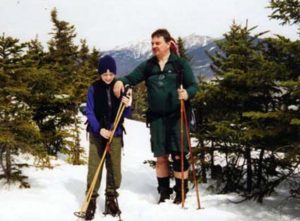
Trail:From Rt. 116, M&M trail to RattleSnake Knob
Date: Saturday 10/02/2004
Attending: Gary & his dog Percy, Gabe, Simone, & John Chicoine
Miles: 5-miles round trip Time: 4 hrs.
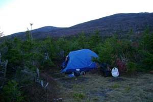
AMC huts, / shelters / camping site: The Notch Visitor Center
Weather: 50 degrees, partly cloudy.
We’ve finally taken some hike time to check out this range. The Mount Holyoke Range sits in the middle of the Connecticut River Valley running west to east with the Connecticut River splitting the range into the Mt. Tom, and Mt. Holyoke ranges. Because these ranges stand alone surrounded by miles of flat farm lands, these “hills” present themselves as monolithic towers. To be frank, the highest of the peaks between both ranges is only 1200ft. None the less they are within under a 1 hour drive and we’ve been pointing at them for more than 20 years thinking, someday we’ll have to check those peaks out. Today would be that day.
Once again we had planned to head up north for a high peak foliage hike, but as the weather appeared to be worsening, (predicted cold, cloudy, and afternoon rain) we began to search for other alternatives. Our hiking party dropped to only the three of us due to injury and “higher priorities”, so we decided to head to a location that was least likely to have bad weather. As we pulled out of Gary’s driveway we were heading to the northern section of the Connecticut AT, but within moments of discussion other possible alternatives, the Mt. Holyoke range became the focus of our attention. None of us had ever hiked there, all of us were curious about the range and seeing we were taking Percy (Gary’s 1 year old Welch Corgi) for his first hike, this option met all of our needs.
We weren’t sure of how to find the trailhead, so we just headed in the general direction and figured we’d ask where the trail head was when near it. It couldn’t have been easier to find, on Rt. 116 near the Amherst town line. The visitor’s center is an awesome building and the rangers there were very helpful. We grabbed a few trail maps and hit the Monadnock-Metacommit trail by 8:30. I would classify this hike as an easy to moderate trek on very well groomed trails. For the moderate effort, the summit of Mt. Norwottuck offers fine views over the Connecticut River valley. Another nice feature to explore along the trail is the Horse Caves, (the M&M passes right through them). If you have young kids, plan to spend at least 15 to 20 minutes there. Our trip didn’t traverse the entire range, (having only one car we didn’t want to hike the 11 mile round trip to the end of the park and back. We decided to hike to a great lunch /view spot called Rattle Snake Knob. We started out a little early, so we mostly had the entire hike to ourselves. This gave us the opportunity to test Percy’s hiking character without a leash. The park requests that dogs be leashed, but we were in training for having Percy accompany us as a regular hiking partner on our White Mountain trips. For the most part Percy was an absolutely spectacular hiking buddy. He never ventured out of our sight, he’d return back to Gary when he whistled for him and he never had any issues with obstacles on the trails. Aside from meeting up with one other hiker with a young Black Lab we weren’t over crowded with other hikers, so we didn’t feel bad about breaking the leash rule. (By 12’ish, the parking lot was full and we can only assume the main trail was quite populated, but we weren’t on the main trail at that time (we decided to hike a side biking trail to scout out possible cross-country ski trails). Back to the hiker with the black lab,,, Percy and the Lab immediately went nuts chasing each other through the woods and running up and down the trail with each other. We could see that they would have kept this up endlessly if we didn’t forcibly end the doggy games. Percy is definitely a dog social dog, so much so he doesn’t / has never encountered another dog he didn’t immediately like and want to play with. (Later on during the day we would see that many dogs don’t like other dogs to play with and they would have happily eaten Percy if we weren’t looking out for his safety.)
Percy almost made it through the day with a perfect A+ for “Hiking 101” but we learned something about this little dog’s need for contact with other dogs. At one point during our hike Percy either heard another dog, or smelled him, and couldn’t resist chasing down the scent. He took off down the trail like a coon dog in mid hunt and no amount of calling could distract him from his goal. We watched him bound down the trail leaping over obstacles like he was a gazelle. We continued to watch as we eventually lost sight of him at least a 10’Th of a mile down the trail. Gary finally caught up with him a solid 2 10’Th of a mile away from where he first started running. We believe he finally did catch up with what he was after but we’re not sure how to break him of the behavior, nor why or when he’ll do it again. After we recovered Percy Gary put him on the leash for a 1/2 mile or so and then we set him loose again, he finished the hike out without any more issues.
This area has definite potential for a more hiking and quite possibly some cross-country skiing. We only hiked about 1/4 of the trails on the Mt. Tom and Holyoke Ranges so there are a few more hikes we’re bound to do. This might make for some good winter hiking. Another definite possibility is to use this resource for our Royal Ranger boys. With my troop being between grades 3 thru 5, I think there are some fine possibilities. Unfortunately there is no over-nighting anywhere within the state park and no official over-nighting anywhere on the M & M trail. One of the park rangers did say that some M & M through hikers have successfully made arrangements with the private property owners to overnight on their land, but the land owners don’t want to see day hikers and weekenders abusing the option to overnight.
[Back to the index]
Send out the hounds!!!!
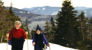
Trail: From Rt. 116, M&M trail to RattleSnake Knob
Date: Sunday 11/01/2004
Attending: Simone, & John Chicoine
Miles: 4-miles round trip Time: 3 hrs.
AMC huts, / shelters / camping site: The Notch Visitor Center
Weather: 60 degrees, partly cloudy.
This was our second trip out to this range. We’re having a fun time getting to know the area. Its turning out to be a nice “quick trip” place for us to hike, get a few nice views, and be back home in just a few hours when we don’t have enough time to do a long trip. What were finding, and hoping, is that this area has lots of potential for great winter/snowshoe hikes, and this section is no exception. I’m wicked looking forward to this winter!
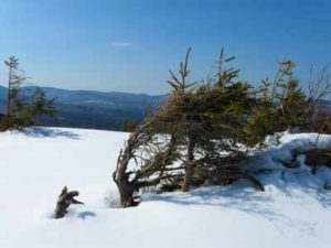
The stretch we hiked was just under 2 miles to Mt. Hitchcock so I figured we were close to a 4 mile hike. From Rt. 116 the trail looks like if climbs straight up Bear peak for a few 100 feet, but they really do a good job with several long switch backs to make this climb quite moderate. Once on Bear peak there are lots of nice views for having only invested 20 minutes of hiking. The stretch over to Mt. Hitchcock has several large gullies to go up and down into so it keep things interesting and keeps you working a little bit while you’re moving. Mt Hitchcock has a great ledge with unobstructed views to the north and west.
I really can’t believe we NEVER made it up to the Whites this October. Life just wouldn’t give us a break. Simone and I were getting cabin fever from lack of trail time and time on the Kayaks became quite sparse this month, so we had to GET OUT THERE somewhere, even if it was just a short jont! It wasn’t quite enough to relieve all the stress, but any little bit helps keep things in perspective.
The views from this hike are very nice, (but you just don’t have that feelings of being high) and the trails are lots of fun. This time of the season the leaves covered the trail several inches deep so it really was like we were hiking through the woods and not on a trail at all. If it wasn’t for the blazes we wouldn’t have known we were hiking where anybody had gone before. The wind wasn’t blowing too seriously, but at one of the view spots there must have been just the right rock formation because it whistled! I mean it really had a very pleasant sounding whistle.
[Back to the index]
Trail: From Mountain Rd, M&M trail to Mt. Hitchcock
Date: Saturday 01/01/2005
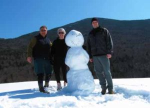
Attending: Noah, Simone, & John Chicoine
Miles: 4.8-miles round trip Time: 3 hrs.
AMC huts, / shelters / camping site: Mt. Holyoke Hilltop house. (closed)
Weather: 50 degrees, mostly sunny.
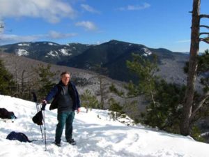
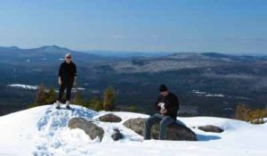
Happy New Years!!! This was our Third trip out to this range. We were officially hiking the Seven Sisters section of this stretch of the M&M trail. Such a surprisingly nice hike and a wonderfully warm New Years Day. Although this trail never progresses past a moderate grade, and the highest elevation is hardly more than 1000″, this trail is full of great stretches of open ledges with views in every direction. Maybe it was the warm sunny day with the open forests of leafless hardwood trees. Maybe it was the open ledges, or the up and down scrambling, or maybe it was just that it was New Years day, but I loved the section of trail and could see us hiking it pretty regularly.
[Back to the index]
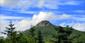 Camels Hump is one the most prominent mountains in the state of Vermont. Although as far as 4K’s go it just barely makes the grade by a mere 83 feet, it (Like all the 4K’s in Vermont) draw a peak pager attention. One of only 5, 4K’s in Vermont, Camels Hump offers people driving through the central section of Vermont spectacular vistas from any high spot within 50 miles of it. It’s one of those mountains that keeps you peering and pointing at it like a little child every time a clearing on the side of the roadway opens up a momentary view.
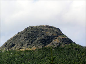 The hike up Monroe trail was very typical of any New England 4K. To say that we really couldn’t come up with anything of any particular note about the trail emphasizes just how typical it was. We did experience some manageable snow on the upper sections of the trail, (Simone was in sneakers.), but other than that, we got nothing… Within 100 yards of the summit, we reached an open plateau clearing above the tree line where quite a few other hikers has gathered in kind of a Pre & Post summit stop. The summit itself is a bit of a rock scramble to a small pinnacle of a knob that really doesn’t have enough room for more than a small group of people. For this time of year and considering the base was so warm, we were surprised to see that the sumit scramble was going to be up a snow path. I was experiencing a serious buzz on the summit from the excitement of the climb, the adrenalin of the hike, and the caffeine from a large, (but tasty) Green Mountain Coffee! (I DON’T DO CAFFEINE!) I felt like I was going to have a freaken heart attack up there!
 Not a good idea! We hiked over the trestle, (that was cool) but it was a dead end street. We never found a trail sign. We tried a few “possible” (well packed in) trails only to find that they just hiked up to ice cliffs for the ice climbers. Eventually we hiked back to where the other group of hikers hiked under the trestle and into the bowl. We decided to follow suit, but it was now 12:20. We’d lost a full hour. The hike into the bowl got quickly seriously steep and we post holed a lot, but we continued to follow the path. (We figured if nothing else we could at least watch the ice climbers climbing every ice flow lining the bowl. Once we got well into the bowl we noticed several hikers hiking past one of the ice flows and up into the side wall. That had to be our trail. We pushed onward and upward, 900 feet in 3 tenths of a mile. Deep snow, post holing, ice covered ledges we had to crawl up. We had no idea we were even close to the cliffs, but we just pushed on. I needed a recognizable milestone to let me know if we were on the right trail, (I was quite sure we were), and to let me know ju
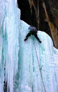 st how much of the trail we had covered. We finally hit the milestone we needed, the view spot at the top of the Frankenstein Cliffs. What a spectacular location. That spot made the strenuous effort worth it all. Unfortunately, it was now 1:30. We had hiked less than 1 third of the loop and we weren’t familiar enough with the trail to attempt to complete the rest of the loop. At this point we decided the devil we knew was the better option than the devil we didn’t. In retrospect I have no doubt we could have hiked out the rest of the loop and that it would have been easier, but winter is no time to push the daylight hours, on an unknown trail. Going back down required a few short butt slides on the ice and snow, we opted to trudge through thigh deep snow out of the bowl rather than try and hike down some of the steep trails that other people but slid for 100 feet or more.
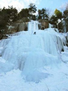
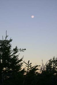
 have asked for a nicer night, (low 30’s), full moon, and a crystal clear sky. Watching the Moon come up over the Kinsmans was even better than watching the sun set over the Green mountains of Vermont. The entire event was picture perfect.
 =========================================
 to be tiring combination to hike up on. Simone used her snowshoes for the entire assent, Gabe and I packed ours up. Simone just had to use them one last time this year. The temps were hot enough that we hiked in t-shirts and shorts. Un-knowingly, we had picked the trail less traveled; We were the first to break trail all the way up! I couldn’t believe no-one had bagged this mountain over the weekend. (This was a good thing). Especially on this trail because it is so well marked. I have never seen a trail in the Whites this heavily marked. When we reached the place where the south trail, converges with the north branch of the loop, we were blown away by how heavily that trail had been hiked. There must have been a hundred people that used that trail over the weekend. The summit of Indian Head is really nice, with some great views of the Franconia Range. We spent about 20 minutes on the summit, and headed back the way we came. As soon as we got off of the steep knob, I decided we should try trail running through the snow. It was a blast!!! The snow had softened up substantially, so we were slipping, sliding, and post holing to mid calf, like a bunch of drunken fools, whooping and laughing at ourselves all the way.
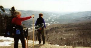 We must have run off a mile or more of the trail. We heated up so much we started a snowball fight just to cool off. We originally intended to hike the Benton trail up the back side of Mt. Moosilauke, and after driving 1.5miles down an unplowed road, we reached a closed gate, 1.5 miles from the already 3.9 mile trail, we just couldn’t do an 11 mile hike. (It would be nice of the AMC book mentioned the road is closed in the winter.) So, we didn’t get to Indian Head trail until 10:30, but we still got back to the car by 2:00. I like days when we can get up there, hike, stop at LL-Bean, and be home by 6:00PM. And although I would most likely never bother with this trail in the summer, I highly recommend as a winter hike. But use the south branch of the trail, and avoid the crowds! Come to think of it, this is one of the few hikes in the whites that we didn’t see other hikers all day. Note! We’re not snobs; we actually like it if we see a few other hikers.