This is the beginning of an E-book that I am working on. It is unedited, unorganized, and very rough in its current form. I figure if I have made this much of a commitment, it may help motivate me to continue with the effort.
================================
Trail Gibberish
====================
Index:
Prelude
The Call Of The Wild
Trail Nourishment
Keeping Hydrated
Hiking Poles
Essential gear:
Footwear
Backpacks
Sleeping Pads
Exercise
Clothes
Prelude
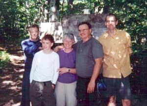
From time to time I get E-mail from people asking questions about hiking. Now I’m the last person on earth in any position to give any advice about hiking from a qualified standing. But my family and I have spent some time out on the trails and we do have some experience with multi-day family hiking. I’ve heard it said, “A man with an experience, is never at the mercy of a man with a theory”; and so, what follows is simply the knowledge that I have acquired through my family’s very real experiences. Please understand that this knowledge may evolve as I gain more experience but for now, this is my story and I’m sticking to it.
______[Back to the index]
Keep close to Nature’s heart… and break clear away, once in awhile, and climb a mountain or spend a week in the woods. Wash your spirit clean.
John Muir
The Call Of The Wild:
I guess a good place to start, is to speak to the question of “Why Hike?” or more importantly, “Why Hike the High Peaks”. Obviously there is no one answer that covers this topic for everyone. For that matter there isn’t even one answer to this question for any one person, for any length of time or for all hikes. Why, go through the physical, mental, emotional and financial ordeal that hiking the New Hampshire White Mountains 4000 footers involves? For the Chicoine family, hiking the 4K’s is quite an ordeal. We live 3 hours away from the closest official 4000 footer. We have to leave our house by 6AM, just to get to the trailhead by 9’ish. Then regardless of the duration or difficulty of the hike, we still have another 3 hour drive to get back home. Before we started peak bagging we were content flatlanders. Gabriel, our youngest was enjoying scouting, and the occasional local hikes around southern New Hampshire, and Massachusetts. One day in church a close friend and fellow Royal Ranger leader leaned over to Gabe and mentioned, “If you and your family liked hiking Mt. Monadnock, I know a trail up Mt. Washington you’ll love”.
We had never hiked any of the White Mountains before. It took our family 20 years (3 kids, 6 years apart, youngest was now 9,,, you do the math). to get matched up age wise to begin attempting serious hikes. Simone and I never hiked our very first 4K, (Mt. Washington), until we were in our mid 40’s. I was old. (And I haven’t gotten any younger since.) I was way out of shape. (And I haven’t gotten in much better shape since.) About this being out of shape thing; I was never a couch potato, I considered myself in relatively good shape, until I bagged my first 4K. I was fat! (not phat!) (And I haven’t gotten any fatter since.) (But I have gotten Phatter since!) I’m somewhat afraid of heights, mostly afraid of standing on the edge high cliffs. I worry for several days before the more challenging, or overnight hikes. I worry about everything that could go wrong. (Lots of things could go wrong, but we’ve never had any of them happen.) Maybe that’s because I worried about them. I worry about every ach and pain I feel, as I’m lying in bed at night unable to sleep while my mind goes over every detail of the trip. Sometimes I even begin to go through symptoms of panic and depression. Does this sound like I’m having fun yet?
(1.) My easiest and quickest answer is simply: because Simone is there. Simone loves it. If she were not there, neither would I be. Oh, Simone and I would probably do lots of flatland day hikes here in the southern New Hampshire and northern Massachusetts region, but that is far from the same thing as backpacking/peak-bagging the 4k’s in the Whites. There are hundreds of miles of trails (Outside of the Whites), to hike all across New England, many of them starting within 20 minutes of my front door step. But! Once you get vertical fever there just aren’t many good remedies other than a really good does high summit. Unfortunately,,, the cure just doesn’t last that long before you get the need to get high again. All it took was one trip up Mt. Washington, with a follow up hike to Mt. Moosilauke to get Simone what you might call, level 3 addicted. The only 12 step program that works for her are the 12 steps from the car to the trailhead. Now I’m not saying the rest of us don’t love this need to get vertical, but Simone gets down right cranky if we don’t get up there often enough.
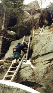
This high peak fever is dam hard work for and old guy carrying an extra 35 lbs. (and I’m not referring to my backpack either)! There have been times, usually at the hardest part of the trip, when my heart is pounding, my temples throbbing, my lungs burning, and my legs almost at the point of collapsing; I look up the trail at Simone and think to myself,,, If I could just catch up to her, I’d push her off this dam mountain and I could go home. Can’t she see that I’m going to die right here on this very spot! My body is going to explode in one last powerful heartbeat! But NO! She keeps on climbing, just out of reach. Often, that’s the time when Gabe will hang back with me and share in my misery. He and I look at each other and he encourages me with the glance that expresses the shared, unspoken thought, “Why in the Name of God, are we doing this again?” I can see the expression in his eyes as he shakes his head looking at me,,, “look at you, you look like your going to die!”, as he breaths out the question, “You going to make it?” Half hoping I say, “No, I can’t do it, lets turn around and leave her here”. But I never do. I dig my poles into the side of the mountain as if to try and kill it before it kills me. Pulling and dragging myself up the side of the slope with every ounce of strength, gasping for air like a fish tossed on the hot sandy beach. The sun burning through my thinning hair, (or sometimes rain and cold wind chilling me to the bone.). Sweat flowing down my brow soaking my entire body, sloshing in my boots. All to reach another little wooden sign nailed to a post with the name of a mountain routed into it. Or even worse, to find a sign that tells me that I haven reached the summit yet and I still have several 10’ths of a mile to go! I die a thousand deaths.
Flash forward into the car just a few hours after this scene: There we sit in such a stench of stinky feet and sweat soaked poly-propylene. (One time we stunk so bad that when I rolled down the driver side window to place our order at the Mc’Donalds drive up, the woman at the window closed her window and completed taking our order over the speaker.) Any way,,, almost every time; The minute everybody has settled into their seat, even before I have a chance to start the car,,, this is exactly when and you can hear the words of absolute insanity as we all proclaim, “What a great hike!” —- Now I’m not sure I’ve given you as much of answer of “Why Hike the high peaks” as I have given you reasons not to!
Now this answer only begs to have the next obvious question answered, Why does Simone love it? I’ll have to get to that later. (You see I only work on this at night and Simone is usually too interested in sleeping to contribute her thoughts to this foolish gibberish.)
Nature is full of genius, full of the divinity; so that not a snowflake escapes its fashioning hand.
Henry David Thoreau
2. Now for a more complicated reason why I hike or for that matter why I seem to do almost everything outdoors that my tired old body can endure. Hiking is one of the best activities I can do that puts me in direct extended contact with the result of the creativity of the hand of God. Imagine that! God Himself put all this here for us (me) to enjoy. It speaks to my soul about the love of God for all of mankind. Nature, especially the unspoiled nature found only in those special spots that most people never see, reveals the character of God’s infinite creative drive; that same drive that created man from the mud of the earth. It teaches me about His magnificent Holy Spirit more than any sermon could ever do. When I’m hiking I have time to focus on Him and His handy work and it puts my spirit at home in the garden (or as close to the garden as we can ever get here on earth.). On the trail I have time to erase the inner-office life that is my alter-life (the necessity of the curse). I have time to purge my mind and really think on what is good, what is important. I have nothing but time to think, to talk, to look and to dream. People these days are filled with separating themselves from anything God has touched with His own hands. Every creature comfort that is now becoming a minimum way of existence is designed to isolate our selves from the very Nature that God has created and pronounced as good. We workout in gyms; never feeling the earth beneath our feet. We drive in cars designed to suppress any/every possible discomfort of the physical world. We breath conditioned air, we drink carbonated, chlorinated, fluoridated, bottled water. We live under man-made light, we don’t ever let the rain touch our bodies; we moderate and regulate the temperatures we live in to within a 20-degree comfort zone. And with every generation it’s getting worse! We crave continuous man-made stimulation for our eyes and ears. Kids today are afraid to go out into the woods and explore what’s out there. Most kids have never slept on the ground, fished a stream, swam in a lake, or stood on a mountaintop. They can’t understand spending time, even a few hours disconnected from their headphones, their video, cell phones, and Internet.
When I hike, I see God’s Glory; The animals, the birds, the vegetation, the landscape, the mountains and the rivers. I have time to experience my own feelings and emotions, and I have a chance to test my abilities and face my weaknesses. The natural world doesn’t lie; if you’re not ready, if you haven’t prepared, if you don’t know what you’re doing, if you make foolish mistakes, you will face the consequences. You can’t adjust the difficulty level on Mt. Moosilaukee’s treadmill. You can’t turn up the thermostat on Mt. Lafayette’s air conditioner. You can’t turn off the faucet on the Pemigewasset. You don’t spit into the wind, you don’t tug on Superman’s cape, you don’t pull the mask off the old Lone Ranger, and you don’t mess around with Jim. (Sing along!!!)
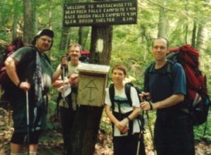
(3.) Another of the great reasons for hiking is the social aspect of the hike. First and foremost, I hike for the wellbeing of my physical and emotional health, and the healthy relationship it fosters within my immediate family. I can think of few other activities that create the type of bonds in our relationships that hiking has done for the members of my family and friends. We’ve shared hours, hundreds of hours of conversation, allowing any topic to play itself out, and to evolve endlessly. It gives you opportunities for free flowing thought, a chance to pursue and develop thoughts and feelings that you may never have formulated without those specific people you share that time with. Sometimes, the discussions are directionless, and purposeless, just hap hazard chatter of old friends thinking out loud. And other times, it’s not. Purposeless.
Hikes (especially multi day excursions) are always a time of sharing common goals, of helping each other through the common struggles, of encouraging each other to go on and work together as a group. The hike environment has the ability to teach strangers to connect with and care for and about one another. It would be a better world if more people hiked with small groups of family, friends and strangers more often. Even if every individual is focused on their own inner thoughts, and the people my wife and I are hiking with don’t have any common bonds and experiences, it’s through the process of the hike, we all share, a common goal, a common accomplishment, and a common experience. We become “The fellowship of the hike”; a stew of age, backgrounds, gender, experience and ability. Each fellowship, takes on a flavor of it’s own and regardless of how hard one might try to re-experience the character of a previous fellowship, it never happens. It becomes something special and memorable when we open up ourselves to learn to feel and share each other’s trail emotions. It seems that in our busy lives, even within the closeness of a healthy loving home we have so many distractions, so many amusements and so little time and reason to connect with each other. I have felt unity, fellowship, equality, companionship, compassion, and love within the fellowship of the hike. I have had clarity of purpose, and value, and family. I have had my spirit renewed and refreshed when I felt like I couldn’t take another moment of what the world does to me when I am off the trail.
Relationships with our friends. We have had the pleasure of sharing so many great experiences with good friends on the trail. There is something about sharing a separating experience of extended days or even hikes of just a few hours with a friend that builds a special kind relationship with that person. There are moments that we have shared with our trail friends that I/we will remember always and having shared those moments with them is most of what makes those moments special. The dynamic of the group that exists in this type of natural experience is like no other; it’s much like an extended family. A can’t remember a hike when if one of our many hiking friends wasn’t there to share a special moment with us, that we didn’t sorely miss them, and verbally pronounce how we wished they were there. When you spend extended periods of time with someone, sharing goals, interests, struggles and the simple joys found on the trail, you strip away the pretences and politics of people in our daily High-Tech existence.
As a Royal Ranger (Scout) commander, I spend countless hours with the boys in my group at our regular weeknight meetings. It’s my intent that I will foster friendships and personal relationships with as many of the boys as will let me into their lives close enough to make a lasting connection; but I can say from years of experience, It’s the boys I have the opportunity to spend time on the trail with, that my relationship with grows beyond, “Commander to scout” into a true personal friendship.
On the trail the strengths and weaknesses of each of the members of the group all become part of that group’s character. The dynamics of large groups is totally different than that of small groups. I can’t remember a hike that even if we were glad to be off the trail, we didn’t have some sadness that the experience was over.
Hikers. Every hiker out there has their own agenda but I know they as well as I share an unspoken commitment to help the other out in time of need. In no other place can I walk past a stranger and know that they could and would, set aside their own agenda to help a fellow hiker in need. Almost every hiker we’ve passed on the trail passes with a comradery, respect and fellowship. Our experience has shown us that by-in-large, most people we’ve shared a hut or a camp site have been friendly and respectful towards us; and if per chance you meet that person again on the trail, it’s much like a family reunion, even if you can hardly remember their name.
______[Back to the index]
Trail Nourishment: (Real people, Real food)
Make no mistake about it; thoughts of FOOD somehow begin to consume even the purest hiker. And even though we never deprive ourselves of adequate food on our hikes, (And we are only talking about several days of being on the trail), food always becomes a primary concern. We talk about what we plan to eat on the way home. We talk about our favorite foods. We talk about the best food we ever had! Even on a day hike food always has it’s time in the conversations. Maybe because we are burning off so many calories we feel justified at rewarding ourselves excessively with it. Or maybe absence makes the heart grow fonder. What ever it is, food is the hikers fantasy that drives him back to civilization.
I can remember on one hike at about the middle of the second day. We had been hiking for 5 hours above tree line on Mt Adams; When in the midst of conversations of unbelievable beauty, 90-mile vistas, standing below a powerful cloud-covered ceiling that we could almost reach up and touch. From out of my sub-conscience came the words, (in full conversational voice, as though I was being spiritually driven to utter these words), “Real people, real food”. It was so unconnected to anything that we were talking about. It was like I was possessed! If you’ve ever stopped in Tilton NH. off RT93 on the way to the Whites, you’ll recognize this phrase. It’s painted on the side of a 50’s style diner, located right at the off ramp. I’ve never eaten there, but some of my hiking buddies don’t miss the opportunity to do so. I was speaking out a fantasy of roadside diner Roast Beef with mashed potatoes and gravy with peas and an ice-cold glass of Coke.
On day hikes lasting 6hrs. Or more the food is primarily there to provide an emotional break from the endless miles. I wish I could say otherwise but after the peak is bagged, the goal has been reached and the second half of the hike well underway; sometimes it does get monotonous. We tend to pack food that provides some entertainment value to help with the long stretch back to the car. After all, we want to look forward to the next hike. We pack lots of chocolate, cheese, trail mix and dried fruits. (Watch the dried apples though, they give you wicked gas). Variety is a key here. I don’t think I’m ever going to eat another bagel on the trail.
On our overnighters we pack tight, & light. I use a 2.5 quart aluminum camp pot. The fry pan portion (has the handle) off one of those $3.00 aluminum mess kits fits perfectly as the lid. Inside the pot I can fit my stove, (Primus Light with Piezo Ignitor) 6 packets of instant oatmeal, 6 tea bags with sugar, 2 packages of Ramen Noodles, (crushed and in a Ziploc bag, without the flavor packages) and 2 packages of Knorr Vegetable soup. (Breakfast and supper for 3, for 2 days.) I tie the lid and pot together with a bit of synch strap, so small rodents can’t get into it. We’ll bring the usual assortment of day hike snacks and if I think the second day might go long, I pack a couple of Pop-Tarts each. We bring hard bread and PB&J for sandwiches for lunch. We’ve never done any extended hikes longer than a week, but Knorr makes a variety of instant soups; so if we spend a week on the trail, I do the same arrangement with the Ramen noodles and use a variety of the soups for the base; I dry corn, peas, carots and meat; and add these (app a 1/4 of a cup each) to the pot. I spice up the dried meat so we can eat it like jerky if we want and it adds lots of flavor to our stew. I almost always pack a clove or two of garlic with each meal, (I always cook with it at home, so I like it on the trail too.) Besides, Garlic could double as an antibiotic if needed. We carry a few plastic spoons for the soup, & we eat our oatmeal out of the bag, cooked and uncooked and we eat and drink our tea, out of paper coffee cups or out of a single plastic coffee cup; We never bother with bowls or plates. One very cool diversion from typical trail food is these new Tuna in a package (mayo and all, no refrigeration needed) and flat bread. It’s a bit heavy but we tend to eat this within the first two days. One last note on the Primus gas stove; it doesn’t work under 30 degrees. I think I’ve got to invest in another stove.
______[Back to the index]
Keeping Hydrated (Water, water everywhere, and nothing to drink.)
Keeping hydrated is the single most important activity, (next to walking) which a hiker has to continue to do. There are no exceptions! To that end, a hiker must either pack in all the fluid he expects to require over the course of the hike, or they must filter/treat the water as they go. Here is where the most studious trip planning must be done. Knowing the location of reliable water is critical. If you don’t plan correctly, you will suffer the consequences. A fellow hiker of mine once related an experience where he helped carry another hiker out of the woods due to dehydration. The hiker had been on limited water rations for only a day or more, and unknowingly slipped past the point of rectifying his dehydration problem in the field. Every attempt to drink was met with an even stronger reaction of throwing up. He was weak, he was delirious, he was very close to passing away, and his body needed fluid from an IV.
Here’s an example of one of our trips. We were spending two days on the trail. According to all my research, we would have reliable water for the first 3 hours on the first day, (until 12:00). We would not be again be passing any reliable water until the later part of the second day, (app 2:00PM). For the first 3 hours of hiking we only packed what we could drink during that three hours. When we reached the point of the last reliable water, we drank our fill, and filled all the bottles; 8 liters for 3 of us, for the next 26 hours. I wanted 1 liter each to finish out the next 3 or 4 hours it would take us to get to our camp site. I needed 1 liter for the soup we were having for supper, I needed I liter for tea and oatmeal for the next day’s breakfast, and only 3 more liters to finish out 5 more hours of hiking to get to my next source of water. Gabe carried 2 liters, Simone carried 2 liters, and I carried 4 liters. We started drinking out of my water supply first. That was a lot of water, but as you can see we were on limited water rations between 9:00 AM. and 2:00PM on the second day. The day was cool and rainy, had it been hot and humid, we would have been short on water.
A hiker’s tip, “Drink your fill, fill your stash and head for the next reliable water.”
We used to just drink water, or some of the lightly carbonated flavored drinks to spice up the day. These days we have all come to the conclusion that the Sport drinks (Gatorade, or Power-aid, I’m sure others are as good or better) help our stamina measurably. Now, the only time we’re drinking plain water is if we’re drinking out of our SafeWater filter. If I have to bother to fill bottles, we’ll mix up some sport drink.
Here’s an interesting approach, although I don’t think I plan to do this. We have a hiking friend that is a long distance runner and over the years has trained himself to force down an entire liter of fluid in one sitting before he begins a run or a hike. In order to avoid frequent stops for hydration on a long hike, he’ll perform this ritual at regular intervals as he feels he needs more hydration.
Symptoms of poor hydration: Headaches, Bonking, an inability to regulate your body temperature, muscle cramps, and no sweat. Anything past Headaches and Bonking could get you in real trouble.
______[Back to the index]
Backpacks. (Get this monkey off my back!)
Everybody wants to know, what backpack is the best? Internals? Externals? I still hike with a Kelty Tioga (the old industry standard external frame pack), but I can’t tell you how many times people stop and comment about why I’m backpacking with an external frame pack. One time out, just below the base of Owls Head, an elderly gent, late 60’ish stopped and pointed and stared in awe, then reported “I ain’t seen one of those out here in years”. Come to think of it, neither have I. So I guess popular opinion would have it that Internal Frame packs are the only way to go today. Never having loaded one with 40Lbs and spent a few days with one on my back I would be hard pressed to confirm or deny. But I will say this; I don’t put an external frame pack on my wife of or my Son. For them we have MountainSmith and Jack Wolf Skin. The Jack Wolf Skin Trailhead II is in my opinion “The best pack money (under $200.00) can buy.” Unfortunately the company was purchased by a big conglomerate and they no longer make backpacks. “Big conglomerates suck.” Political commentaries aside; back to the packs. Fit and function is what it’s all about, (In that order!).
Does it fit? Fitting a backpack (either external or internal frames), is one of the most important exercises a person planning to have one of these on his back for any amount of time. Unfortunately most people are too modest to “bother the poor salesman” for up to an hour adjusting and readjusting, varying the weight, even switching hip belts on some models that have completely customizable packs, only to admit that you’re just trying it out in your long quest to try as many packs as fall into your function definition. Unless you are already a pack expert, (you shouldn’t be bothering to read this) you really should have someone that knows the pack you are looking at so it can be properly adjusted. The fitting process should start with measuring your torso length, (from the bump on the base of your lower neck to your hip). Every pack manufacturer lists its span of torso sizes the pack can be adjusted for. (Some of the less expensive packs have no ability to adjust for different torso lengths.) Any good pack should have several adjustments, load bearing adjustments on the shoulder straps and on the hip belts, plus they should have synch straps that let you compress the load within the pack to keep things from shifting as you walk. Some internal frame packs are very sparse, with no access to the your gear other than through the top and no pouches to carry often used items such as water bottles. This gives the pack a very narrow profile on the trail (Easier to crawl over or under blow downs, and for bush whacking). Most External packs are loaded with compartments in which you can sort items to your hearts content but these packs are somewhat wider and more cumbersome on the trail. (Mine tends to reach out and grab onto limbs that I didn’t even notice were there). Internal packs tend to lie flat against your back helping with the hikers stability giving you the feeling that the pack is part of you. External packs are designed to lift the pack off your back, allowing some airflow between you and the pack but this feature tends to make the pack shift from side to side as the hiker moves. I can’t imagine that a hiker can ever become one with an external frame pack. Internal packs for the most part are designed to keep most of your gear inside the main tube. External packs encourage you to strap things onto the frame like the family station wagon on vacation. Whichever pack you settle on you will have to live with it’s idiosyncrasies, as it breaks you in. You will likely be loosening and tightening your straps, belts and shoulder pads giving various parts of your body a rest as you walk through the day. Unfortunately the backpack will be the heaviest single item on your back. My Tioga (even after I’ve trimmed everything I can off of it), still weighs over 6lbs. I HATE THIS!!! I limit my total pack weight to 40 – 43lbs. and my pack makes up almost 1/7’th of the total weight! I HATE THIS!!! Which backpack is the best? I’m still waiting for one that caries the load for me. But until then, I’d go with whichever pack fits you well when it’s loaded with your tipical load.
______[Back to the index] Jump to a guide on Backpacks.
Hiking Poles. (They’re not just for going down any more.)
We never hike without them. Going up, it’s like having 4-wheel drive and I’m not embarrassed to say so. I’m not sure I’d have what it takes to drag this long-haired, over-fed, sleeping gnome up to the top, if I didn’t use my arms to help my legs get me there. What goes up, must come down. (There’s food down there!) and my knees just wouldn’t be the same without my poles. We really prefer the old bamboo cross-country ski poles but they tend to burn out after a hundred miles and we just can’t seem to find them at the yard sales that often any more. We’ve gone high tech lately and purchased EMS (Gabel) adjustable poles. Much-ado about nothing. We seldom bother to adjust the length of the poles on the trail. I don’t feel as safe with these as with the bamboo and 2 pair cost as much as 10 pair of yard sale bamboo ski poles. To be fair to the bamboo poles, the new aluminum poles just might burn out after a few hundred miles too. Plus the best benefit to the bamboo poles was that we hung them out on the front of the garage. If the poles were there we were home, if the poles are gone, so were we! One amusing anticdote; We were hiking a local mountain and on the way down we came across a lady just ahead of us heading off the mountain after a day of hiking. When we caught up to her we started the usual banter about the day and the hike and she happened to comment about our hiking poles. She mentioned that she was trying hers out for the first time, (Her husband had bought her hers for Christmas). But she just didn’t see how they helped her that much; they were too short to do any good. I looked at the poles and noticed that they were 3 section poles and the lower section wasn’t extended. She had no idea that they adjusted. Once I set them for her height she immediately noticed that they really did make a difference. ______[Back to the index]
Essential gear
This is where opinions can get varied. There is gear you need because you use it every time. Gear you almost never use and hope you’ll never need to use it, but always bring it. Gear for a day trip won’t be the same as for an over-nighter.
For every hike;
Maps and guides. Always have a trail map, someone familiar with the trail, or a detailed description of the trail. I believe in over-kill in this area. I study the maps, read the trail guides, search the web, and speak to whom ever I can that’s been there before. That’s part of why I maintain my web site. I’m hoping that it will be one more of the many resources that someone might use to help prepare for their hike. I trust the AMC guides as my hiking bible, and a bring copies of the pages related to my hike with me, along with the map. I try never to hike without knowing what I’m getting into.
A Compass (an orienteering type) (Seldom used, except to spot landmarks from summits.) Having a compass is essential, but I have to add that it is useless to have one and not know how to use one. Take the time to learn how to use one, and practice a few times. Teach everyone that you hike with how to use one, and it is appropriate to say that each person that is likely to leave the main group should have one of their own. Sometimes my son would tend to hike far enough ahead of us so as to get out of sight for a few moments. He doesn’t do this so much any more. Once he wandered down a section of the trail that had been re-routed, and didn’t notice that the log he thought was a blow-down was actually the barrier to turn at. He stepped over the log and ventured straight for a few minutes, while we had turned 90 degrees left for a few minutes. He, (and we) figured out that it had been too long without seeing each other, Simone headed back up the trail, while I ran forward to try and catch up. Needless to say, there was a moment of panic in all of us. Gabe had turned around and was arriving back at the detour just about the time Simone had reached it. A compass wouldn’t have helped in this situation, but if Gabe had gotten lost, he would have been able to use the compass to help find his way back, or at least the highway just a 1/2 mile from where he was lost.
A Whistle (We’ve never used one yet, but always bring one just the same.) I tell my Royal Rangers (ages 9 to 12) to try yelling as loud as they can for just 1 minute. And then, once the noise has quieted down, to think how their throat feels. Then I ask them how they think their throat would feel if they were doing this for several hours. Carrying a whistle is a much better option. In the case where Gabe got separated from us, a whistle definitely would have been the right piece of equipment to be carrying. We have several, and keep them on the fanny packs along side the compass’s) A quick antidote about sound on the trails. We were hiking near the summit of Mt. Eisenhower just as we were breaking out of the trees, and as we stood there looking at the view, and old open cockpit Bi-Plane passed over us from behind. He was so low, and so loud that it freaked us out, as he buzzed us. But we never heard him coming. Sound doesn’t travel well in trees and hills. A kid’s voice after a few minutes of yelling in the forest wouldn’t travel 50 yards.
Sun-block Any season can burn your skin, even when it’s not extremely sunny. Gabe always wears a wide brim hikers hat. I don’t burn easily, but I usually wear a doo-rag for that patch of skin that keeps getting easier to see on the top of my head, and Simone wears a brim cap. We are amazed at the times we get a little burnt when we forget to use the sun block.
Water purifier or Iodine pills (I bring it on every hike, and we use it on every hike.) Fortunately we made what I suspect was a good decision for our type of hiking. We purchased a water filter that is both the filter, and container. I’m not ashamed to use a brand name here, because this product serves us so well for what we need it to do. It’s called “Safe-Water-Anywhere”. I know water purification has grown into a religion, and here’s mine. I know there are better filters, but this one filters everything I will ever encounter in the White Mountains and New England trails. This one carries the water it filters, so it takes up no extra room. This one is inexpensive enough to own and carry several on an overnight trip. This one can’t clog, and there are no moving parts to break. If I were ever in doubt, I can just drop an Iodine pill in the container and the filter helps to remove some of the iodine taste. I always carry the Safe-Water, even if I load it with good water before the hike. The filter is inexpensive enough to willingly replace, and it’s good for several hundred gallons.
A Pocket-Knife. (I Bring it everywhere, use it all the time.) I like my Gerber Multi-tool! So there! I said it. It’s a little expensive $35.00, but I use it all the time. It has everything I need. It makes me feel comfortable, like I’m equipped to handle what ever I need. It’s my security blanket, and don’t mind carrying the weight. It’s lighter than most Multi-tools.
An Emergency Kit. (We bring it on all the hikes, and we use the drugs often.) The emergency kit has a list of it’s own. My kit is just a small stuff sack with junk “stuffed” in it. 1. Assorted bandages. 2. Drugs. (Motrin, Benedryl, Sudafed) 3. Matches with strikers in a plastic film role bottle. 4. A Space blanket. 5. Small tubes of Sun & bug stuff. 6. Small tubes of disinfectant. 7. Small tubes of topical muscle / pain relief. 8. Needles and Dental floss for thread. 9. Whistle. 10. Scissors. 11. Mole skin. 12. A wire saw. 13. Gray tape wrapped around an aluminum tube. 14. Several paper-clips. ______[Back to the index]
Footwear: (feets, don’t fail me now!)
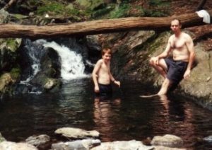
We are becoming amateur podiatrists. Simone and I both have very different foot issues, and are attempting to resolve the issues through the live and learn method. It seems it’s near impossible to find a professional podiatrist that backpacks enough to understand how to address foot problems that are specifically hiking related. Me: After a long hike, I used to get lots of pain in the arches; the pain would carry on through the week. Some mornings I would have to massage my feet for a moment or two just get out of bead without having excessive pain. Those first few steps were a killer, even after sitting for only an hour or more. I’ve solved all that now. I use SPENCO 3/4 inserts, in a firm quality work shoe with a metatarsal pad, as my every day in the office shoe. (I walk most everyday 1 to 2 miles at lunch). The shoes are your typical US postal worker style, and have even been US Postal service approved. (All US Postal service approved shoes have a tag on them by the postal service.) I always hike in medium/heavy weight, traditional all leather hikers; Norwegian welt stitched, with Vibrum soles. Weighing 225Lbs (without a pack), I like lots of support from toe to ankle. The original foot-bed has been replaced with full-length Spenco Hiking foot-beds, in the summer, and Spenco 3/4 length inserts in the winter. I switch for the seasons because I use a thicker sock in the winter, and I want to keep lots of room in the toes for warmth. In the summer, I use a lighter sock and can afford to have the full-length thick pad of the Spenco hikers, under the balls of my feet. Simone: She is still looking for the solution to her problem. Her toes cramp up on decent. The condition can occur instantly within a few steps, or can come on slowly over a 1/4 mile or so. Once it’s there, it’s a sharp stabbing pain that stops her in her tracks. Things that seem to help. Taking Motrin at the first sense of the onset of the problem. Spenco 3/4 arch support inserts in her light/mid weight leather hikers. On lots of our day hikes, she hikes in Merrel hiking sandals. She almost never experiences toe cramping in her sandals. Soaking her feet in the cold White Mountains water. Berkinstocks for almost all of her other time with shoes on. I don’t hesitate to use brand names here, because we’ve tried several other brands of inserts, partial inserts, pads, liners, etc … What I mentioned seems to work for us. Your mileage may vary, but I don’t have a problem recommending you start experimenting with the Spenco products, it just might save you the expense of owning a box full of other products that don’t help. If the trail has a brook close to it’s end, we almost always have a traditional foot washing, even in the winter. What a refreshing/ renewing experience! I can remember one instance when we had just finished hiking at Waterville Ski area, in our shorts and t-shirts. (It was just a bit cold by the snow making guns) We had cracked through the ice, and were wading and splashing about in the pond near the base, as the skiers shivered past us in full Ski bunny suits, staring at us like we were from a different planet. For extended winter hikes with snowshoes, Simone has been using Columbia Bugaboots for the last few years. I’ve recently purchased a pair, but I don’t bother to wear them unless we’re going to be out for more than 4 hours. My regular leather hikers are much more to my liking, and they can keep my feet dry and comfortable for up to 4 or 5 hours. Here’s an interesting fact: A pound on the foot is like 5 on the back. (Worth thinking about when you’re buying boots.) Check the weight!
______[Back to the index]
Jump to a guide on buying and caring for your boots.
Sleeping Pads (Yea right! Maybe the pads sleep, I don’t!)
Now there’s an oxymoron. Sleeping pads. Like there is anything in this world that weighs less than 1lb and is less than 1 inch thick, that is going to give a 230lb. man a comfortable night sleep on rocky ground. The most valuable thing I ever use that helps me get through the night is 3 Motrin’s. I’m not sure if it’s to kill the pain I acquired from the day’s hiking, or from the pains I pick up from sleeping on a sleeping pad. I use a full length Z-Rest closed cell foam pad. Simone and Gabe use 3/4 length self-inflating Therma-Rests. If anybody backpacking thinks they are going to get more than the minimum of sleep that your body needs to get through the next day is foolish, or much luckier than I. The foam Z-Rests are the best choice if you plan to be sleeping on a cold ground. The Therma-Rests are much more pack-able. (The size of the Z-rest is one reason I hike with an external frame pack, It’s bulky.) They do make Therma-rests of varying length and thickness, but the expense and pack-able size climbs substantially too. My only advice is to get what you really need for your planned backpacking situations. I did notice one fellow hiker in his late 60’s in a shelter sleeping on a full length 1 1/2inch thick Therma-rest and thought to myself, if I were hiking at that age I’d be sleeping on one of those too. He slept, I didn’t!
______[Back to the index]
Exercise. “That’s not fat; It’s muscle, Relaxing.”
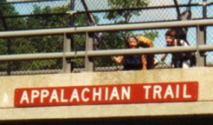
Don’t get me wrong; this is hard work for a 50-year-old man. This is hard work for anyone. Strapping a backpack on your back and knocking off a day’s worth of miles will take a lot of effort from anyone that tries it. It doesn’t take a genius to connect the dots on this one. You don’t have to be in superhuman shape, but I defiantly recommend that you “work up” to a 4K by hitting the trail in gradual steps. Regular exercise stressing the legs, arms, heart and lungs definitely makes hitting the trail a bit less difficult each time you attempt to bag a 4K peak. Backpacking anyplace with hills or mountains involved is going to take its toll on a body. If your body is prepared to stress itself under the load is more likely to do so without injury. I don’t have a trainer configured exercise routine, I do how ever keep very active riding bike, walking (up hill whenever possible) cross-country skiing, and of course regular hiking and peak bagging. Backpacking itself is a very unique activity that would be hard to emulate in a gym. I remember the evening our hiking team sat down to plan our Massachusetts AT section hike. We looked over the maps, evaluated the average elevation gain for each day, and calculated our mileage for each day to complete the 100mile trip in 7 days. We packed the days with 10, 12, and 16 mile days, and when we added up all the miles within the 7 day limit we celebrated our planning as though we had hiked the trip. As reality would have it, the temps were in the high 90’s, the humidity was so thick you could drink the air, and the hills were real hills. We were lucky to make 8 miles a day. The trip took us two separate stretches, and a total of 10 days. How can you emulate these conditions in a gym?
______[Back to the index]
Clothes. “Pigs in a blanket”
Clothing is a one of the most essential components to enjoying a successful hiking and or especially backpacking trip. Without a doubt there are so many varieties of clothing options and of all the hiking “gear”, clothing has been making the most constant and drastic improvements over the last 20 years. Of all our expenses, clothing has been one of our largest and continues grow as we continue to expand our hiking/backpacking experiences. Obviously we are not the only people that are experiencing this phenomenon, just go into any outfitter store and it will look almost like any TJMax or Marchalls other than a few added backpacks and tents. My motto! “Real backpackers never buy at list price!” we have too many other things to buy. We are very fortunate in that we can/do make most of our own clothes; and by doing so we know junk from quality. Quality = “Malden Mills PolarTec materials. Junk = everything else. Other than that I have no strong opinions about the subject. Wool is good, but not worth the bother and doesn’t compare to the high-tech stuff.. Gore-Tex might be good but from the mixed feelings across the industry, I can’t afford Gore-Tex clothes just for the name. Our first layer starts with PolarTec Micro Fleece or Powerdry, our next layer is PolarTec 300 vests or jackets, and our third layer is PolarTec WindBlock. We do use an EMS PowerStretch Shell for hard rain gear. We use various Polartec materials for mittens, headbands, hats, and balaclavas. I’ve had one pair of EMS convertible pants that I’ve worn on every hike, campout, backpacking trip for the last 5 years. If I need more then one pair of pants for an extended venture, I’ll bring a few pair of swim-Trunks. We all have a few EMS Polyester button down shirts. Regardless of what we wear, everything gets soaked with sweat, dirt and mud. After one of our particularly sweaty hikes, we stunk so badly that the lady at the drive-up window of McDonalds closed the window when we drove up. Usually the Stink-O-Meeter is a good gage of how much fun the hike was.
______[Back to the index]
 We were back at the campsite by noon and the stove performed well enough to heat a few cups of oatmeal for lunch. The day never reached above freezing and after noon the temps began to drop again. We met a couple of hikers that hadn’t known the “eating out of your hands” habit of the Gray Jays. One of them immediately jumped up to try it, while the other looked on a bit skeptical. Within a few seconds a jay had landed in the first guy’s hand and the skeptic jumped up in amazement holding his hand full of GORP proclaiming “let me try that!”. Happens every time. We had to warn them not to feed the jays their entire supply of GORP.
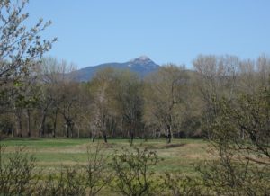
 After 15 years of putting this peak off, (I don’t particularly know why.) Simone finally got her wish to hike Chocorua. (We’ll call it her early Mothers day present.) Everything good we’ve ever heard about this mountain was an obvious understatement by default. No words could ever aptly describe what a wonderful hike this is. The hike up from the south via the Liberty trail is a little bit of a challenge to find the trailhead, but well worth finding. Some of the roads are dirt, but not very bad traveling. The trail starts off along a long old cart road with very slight grade gradually increasing in degree ever so slightly until the trail begins to climb in earnest up the side of the hill. The trail doesn’t have any noticeable flat sections along its length but increases in degree continually until it reaches Jim Liberty cabin at 3.3 miles from the trailhead. The cabin provides an inviting rest spot to relax and catch your wind before this hike gets real serious for the final .5 miles. (It’s very tempting to stop the hike right here! Standing at the cabin looking up (Quite a neck stretcher.); that last 1/2 mile looks quite daunting. And it IS! No fooling around here. It’s time to pay your dues before your great reward. There’s quite a bit of scrambling before you reach the sign for the bail-out loop to pass the summit in inclement weather. The last 50 feet to the summit has some challenging hand scrambling, (One individual we met at that location bailed out at that point after hiking 3 hours only to stop 50 feet from the summit.) DON’T! If the weather is favorable the only real difficult rock scramble is only 6 feet and once you climb over that, the worst is over and it’s just slightly challenging. (Think of it like this. It wouldn’t be one of the most favorite hikes in the Whites if 99.9 of the people that try to summit, couldn’t.) (By the way,,, the guy that decided to bail out, eventually did summit after his friend went back after him and convinced his he could do it.
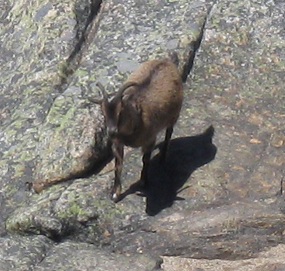 Look mom! A trail Goat! Yup, That’s a definite first. A girl brought her goat up the mountain with her. Unfortunately they couldn’t make it up that last rock scramble within 50 feet of the summit so they continued over the mountain.
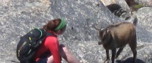
 Some climb for the beauty